The views expressed in this paper are those of the writer(s) and are not necessarily those of the ARJ Editor or Answers in Genesis.
Abstract
Opposite Hellas, the largest impact basin on Mars, are the Tharsis volcanoes, the largest volcanoes in the solar system. Directly opposite the center of Hellas impact basin is the volcano called Alba Patera. Alba Patera is the largest Martian volcano by surface area. Coming off of the Tharsis plateau is Valles Marineris, the largest known valley in the solar system.
The unlikely geographic relationship between these gigantic features suggests a cause and effect relationship between them. This implies a global Martian catastrophe comparable in scale to the Genesis Flood.
The twin rovers, Opportunity and Spirit, have provided evidence in support of a Martian geological catastrophe. Data sent from Opportunity (and from orbit) show that it landed in an area that was catastrophically flooded from the south forming a large splat zone in the north.
Current data provide an excellent starting point for a young Mars catastrophic geologic model allowing the formation of a core young Mars model.
Keywords: astronomy, Mars, impacts, volcanoes, Hellas, Tharsis plateau, Alba Patera, Valles Marineris
Introduction
Mars captures the imagination more than any other planet. No other known planet has as earthlike an environment as Mars, but yet they are still very different. Mars is enough like Earth that evolutionists have expected to find life there, but none has yet been found.
Probes sent to Mars have sent back gigabytes of data which have been made readily available on the Internet. This wealth of data not only provides a unique opportunity to watch uniformitarian geologists build a model of planetary history from scratch, but it also provides creationists with an opportunity to do the same.
In this case the raw data are readily available to anyone with a computer, so that research can be done even with the smallest of budgets. The result is as nearly level a playing field as is likely ever to exist between competing ideas.
Using this wealth of data has revealed a relationship between three different major Martian geological features, all of which are among the largest of their type in the solar system. These geological features include the Hellas impact basin, the Tharsis volcanoes, and Valles Marineris. The relationship between these gigantic features is unlikely to be a result of chance, suggesting a cause and effect relationship between them. This implies a global Martian geological catastrophe comparable in scale to the Genesis Flood.
The idea of this Martian catastrophe is supported by additional evidence from the twin rovers Opportunity and Spirit. Opportunity seems to have landed in an area that was catastrophically flooded despite uniformitarian claims of it having been a long-standing sea.
Uniformitarianism on Mars
Even on Mars, uniformitarian geologists are so locked into the idea of geological ages associated with a geological column, that when they see different layers of rock they think geological ages. Researchers at JPL (Jet Propulsion Laboratory) are already claiming that the rock layers, found by the rover Opportunity, are billions of years old before even one radioisotope has been measured (Chang 2005). It has been stated that these layers represent different epochs of Martian history despite evidence that they are only a local occurrence. They do this based on their preconceptions resulting from how they think the solar system formed. It is evident that by the time these rocks are actually radiometrically dated, uniformitarian geologists will already “know” how old they are so that they will know which results to disregard as contamination and which to make public.
Creationist Opportunity
Mars presents creationists with an opportunity to build a model of planetary geological history from scratch. Furthermore, because the raw data of JPL’s Martian probes are freely available on the Internet, Mars can be studied on even the smallest of budgets.
Uniformitarian theories of Martian geological history will likely be used against creationists in the future, but because of the availability of the data creationists have the opportunity to be prepared in advance.
Martian Geographic Oddities
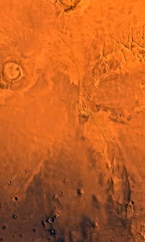
Hellas is not only the largest impact basin on Mars; it is one of the largest known impact basins in the solar system. Hellas is in basically a crater which is about 2,100 km (1,300 miles) in diameter and 9 km (5.6 miles) deep. For comparison Hellas is about half the size of the continental United States and about as deep as Mt. Everest is high.
Hellas’ center is located at about 70ºE and 40ºS. The bottom of Hellas is the only place on Mars with a high enough atmospheric pressure for liquid water to stay on the surface (Phillips 2000). The energy of the Hellas impact has been estimated at about 5.33 × 1026 joules (Spexarth 2004). This is a blast of 1.27 × 10¹¹ megatons which is equivalent to 8.48 × 10¹² atomic bombs the size of the one dropped on Hiroshima (U. S. Department of Energy 2000).
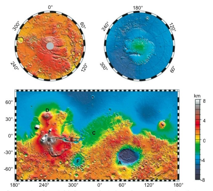
Figure 1. Map of Mars’ global topography. It shows the uneven crater distribution. Retrieved from
http://www.solarviews.com/cap/mgs/mgstopo7.htm. (Courtesy GSFC/NASA). Note:
A Hellas impact basin.
B Tharsis plateau and its volcanoes.
C Meridiani Planum.
D Alba Patera.
E Valles Marineris.
F Argyre impact basin.
The Hellas impact dwarfs any known impact sites on Earth. For example, the famous 1908 Tunguska explosion is estimated at about 500 kilotons. (Hartmann 2003). The Chicxulub impact, thought by evolutionists to have killed off the dinosaurs, is estimated at about 108 megatons and produced a crater at most 180 km across (Kring 2008). Even Earth’s largest known impact crater, the Vredefort dome, is only about 300 km in diameter (Spray et al. 2008). Despite their relatively small size, these Earth impact sites do provide insight into the results of large impacts. For example, the Chicxulub impact would have put so much dust into Earth’s atmosphere that it is accredited by most paleontologists with killing off the dinosaurs. The Hellas impact would clearly have thrown up thousands of times as much dust into the Martian atmosphere.
If the impacting body came from the asteroid belt, the impacting velocity would be about 7 km/s. Using the formula for kinetic energy (K = ½ mv2) results in a mass of 2.2 × 10¹⁹ kg. This is a mass similar to that of the asteroid Juno, which has a diameter of about 206 km (Weast et al. 1983).
Opposite Hellas on the Martian surface are the Tharsis volcanoes. These also are the largest volcanoes in the solar system. Directly opposite the center of Hellas (at about 110ºW and 40ºN) (Malin space science systems 2003) is the western side of Alba Patera’s caldera. Alba Patera is the largest Martian volcano by surface area. Coming off of the Tharsis plateau is Valles Marineris, the largest known valley in the solar system.
Yet another Martian geographic oddity is that most Martian craters form a hemispherical pattern on the surface. Furthermore, the center of this hemispherical pattern is about 30º west of the center of Hellas, placing Hellas near the center of this hemisphere (Figure 1).
Spirit and Opportunity
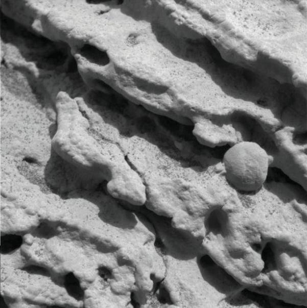
Figure 2. Erosion patterns found by Opportunity. Retrieved from
http://photojournal.jpl.nasa.gov/catalog/PIA05237. (Courtesy NASA/JPL/Cornell/U. S. Geological Survey).
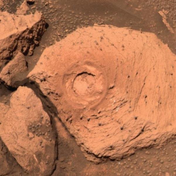
Figure 3. Erosion patterns found by Opportunity, including hematite spheres on sticks. Retrieved from http://photojournal.jpl.nasa.gov/catalog/PIA05830. (Courtesy NASA/JPL/Cornell/U. S. Geological Survey).
In January 2004 the twin rovers, Spirit and Opportunity, landed on Mars and since then they have sent back a wealth of data. Both rovers found that Martian soil is largely volcanic dust (NASA/ JPL/Cornell/ASU 2004a; NASA/JPL/Cornell/ASU 2004c). Many of the rocks examined by these rovers are composed of basalt, a volcanic rock (NASA/JPL/ Cornell/ASU 2004b). Furthermore, many of the rocks seen by Spirit are broken, as if damaged by impacting the ground.
When Opportunity landed in the Meridiani Planum region of Mars, the scene that it showed was strange even for Mars. The soil was darker than that at other landing sites and the ground was covered with innumerable spherical hematite nodules (NASA/JPL/Cornell/ASU 2004e; NASA/JPL/Cornell/ASU 2004h). The outcropping of rocks in the crater where Opportunity landed are layered and show evidence of having been laid down by water (NASA/JPL/Cornell/ASU 2004f; NASA/JPL/Cornell/ASU 2004g). They were also strangely eroded. The rocks had hematite nodules embedded in them (Figure 2) and some had the nodules out on sticks of rock (Figure 3). These patterns have persisted throughout the area explored by Opportunity, though the deeper craters show deeper rocks with layers of different rocks (Figure 4). Chemical analysis shows that much of the rock in Meridiani Planum contains sulfates which are a by-product of the reaction of sulfuric acid and water (NASA/JPL/Cornell/ASU 2004d; NASA/JPL/Cornell/ASU 2004i).
The Meridiani Planum region shows evidence of large amounts of water flowing into it in a catastrophic manner, including an inflow channel at one end and a splatter zone at the other end (Figure 5). This inflow channel has ridges that are consistent with a flow channel and the splatter zone shows evidence of flowing over underlying terrain in a chaotic fashion similar to the termination of a mud-flow. This evidence suggests that Meridiani Planum suffered catastrophic flooding at some time in the past. The fact the craters studied by Opportunity were blasted through layers of rock shows that the flooding happened before these impacts. However, other craters in the area show evidence of having been formed before the flooding in the sedimentary patterns of the craters. These craters have sedimentary deposits up against the crater wall opposite the direction of the flow of water.
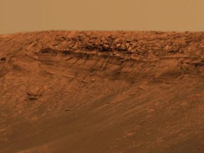
Figure 4. The deep layers of the “Burns Cliff” at Endurance crater. Retrieved from http://photojournal.jpl.nasa.gov/catalog/PIA05869. (Courtesy NASA/JPL/Cornell/U. S. Geological Survey).
Discussion
The Hellas impact would have sent a shock wave around and through the planet that would have been focused onto the exact opposite side of the planet (Alba Patera) from the impact. This focusing of the shock wave would have caused cracks in the crust. Furthermore, if the crust were particularly weak in the area with a pool of magma below it, such a crack would have resulted in a sudden burst of volcanic activity at this point. It is also possible that cracks could have continued along the area of weakened crust forming other volcanoes. This is supported by the fact that four of the Tharsis volcanoes (Ceraunius Tholus, Ascraeus Mons, Pavonis Mons, and Arsia Mons) form a nearly straight line. While connections between Hellas and the Tharsis volcanoes as well as Hellas and Alba Patera have been suggested before (Scott et al. 2001; Spexarth 2004), they have been limited to the basic concept and not as detailed a model as presented here.
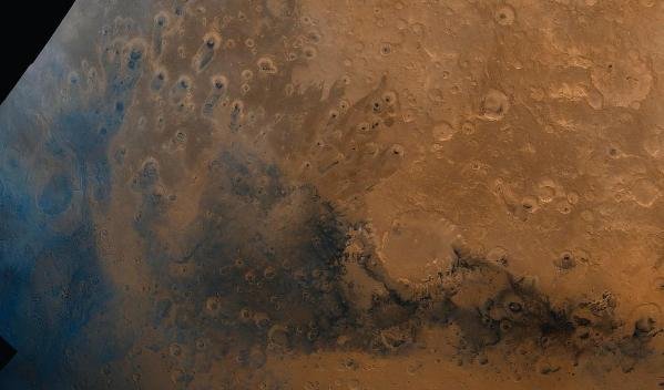
Figure 5. The Meridiani Planum region of Mars, the region where Opportunity landed. Note the inflow channel to the south east and the splat zone in the north. Retrieved from: http://photojournal.jpl.nasa.gov/catalog/PIA00004. (Courtesy NASA/JPL-Caltech).
While no earthbound impacts show this type of effect, Mercury shows that they can occur. Mercury’s largest impact basin is the Caloris Basin. It has a diameter of 1,300 km (800 miles), which is about two-thirds that of Hellas (Hamilton 1995b). On the opposite side of Mercury from the Caloris Basin is a lineated and hilly area about 100 km (62 miles) across where the crust seems to have been broken into jumbled blocks by the Caloris impact (Hamilton 1995a).
The result is that massive amounts of volcanic activity would have occurred, filling the atmosphere with volcanic ash. Included in the mix would be a large amount of sulfur. If the volcanic activity were high enough the ash would increase Mars’ atmospheric pressure to a point where liquid water could exist. Much of the volcanic material would form the volcanic mounts. In Tharsis, the concentration of volcanoes would have caused a pile up of volcanic material forming much if not all of the Tharsis plateau. The remainder of the volcanic ash would have covered the planet, becoming a major component of its soil.
At first glance the hemispherical pattern of craters seems hard to explain by the resurfacing of the lightly cratered north. The fact the Hellas is near the center of this hemispherical pattern further complicates the problem, but the relationship between Hellas and Tharsis provides a solution. A closer look shows that the southern dip in the crater pattern is entirely part of Tharsis, suggesting that the plateau likely covered part of the southern highlands making them look more hemispherical (Figure 1). This is also supported by crustal thickness measurements from Mars Global Surveyor (Zuber 2000). Furthermore, the fact that Hellas is on the opposite side of the planet from Tharsis would naturally place it near the center of hemispherical pattern.
Since the northern lowlands have a lower elevation than the highlands, considerably more of the volcanic and ejected impact material settled in the northern region of the planet. This is because it is easier for dust to be blown from a higher to a lower elevation. This process would have been aided by the fact that the most, if not all, of the volcanism occurred on thinner lowland crust. The result would be a nearly complete resurfacing of the northern lowlands.
Valles Marineris is a large rift valley about 4,000 km (2,500 miles) long, which is about the same size as the continental United States. Its identity as a rift valley is supported by a sudden decrease in crust thickness under the valley (Zuber 2000). This suggests that the crust has been stretched in that area. The cause could have simply been the seismic activity associated with the Tharsis volcanoes, but the proximity of the Argyre Impact Basin offers another possibility. The shock from this impact may have rotated the crust under the southern part of Tharsis, stretching crust at Valles Marineris and compressing it to the southwest.
The flooding at Meridiani Planum seems to have originated at about 12ºS and 31ºE. This is based on the patterns of deposited material in the surrounding terrain. The eruption of water from underground seems to be the most likely source of water, since underground water would be under pressure causing it to be ejected at high velocity, resulting in the erosion of considerable amounts of material to become the sedimentary rocks found by Opportunity. However, an impacting body cannot yet be eliminated as a possible source, because an eruption point has yet to be found.
While some of the floodwater went in different directions, most of it would have rushed downhill into the Meridiani Planum region. This water would be loaded with material, some of which was deposited over the area explored by Opportunity. Since sedimentation in moving water can form multiple layers simultaneously (Berthault 2008; Reed 2008), such a sudden flow of rushing water could have easily laid down the rock layers observed in the Meridiani Planum region. The leading edge of the flowing water would form a splat zone, as is observed to the north of the Meridiani Planum region.
Once flooded, the water would likely have remained as long as the volcanic ash covered the planet. As the volcanic ash settled the sulfur would have reacted with the water to form sulfuric acid. As a result the environment of this temporary lake would have been more like that of a car battery than an ocean. The presence of concentrated sulfuric acid would have aided the formation of the hematite spheres that Opportunity found all over the area.
The craters studied by Opportunity seem to be the result of impacts that occurred while the area was flooded. The concentrated sulfuric acid would have eroded the exposed rocks producing the observed erosion patterns, including hematite spheres on a stick of rock (Arlauckas et al. 2004).
Given the evidence that the Earth received a significant number of impacts during the Flood (Spencer 1998), and that the size distribution of craters show that the Earth and Mars were hit by the same population of objects, it is likely that these events occurred at about the time of the Genesis Flood. Available data is consistent with such a bombardment, since most of the impacts on Earth would have been spread over the year of the Flood, with a smaller number afterward.
The model presented here is a starting point. More research is needed, not only in the areas mentioned, but the rest of Mars as well. Mars presents an excellent opportunity for creation research. There are many riverbed-like channels that suggest Meridiani Planum was not the only part of Mars to have been flooded in the past. It is hoped that this paper is just the beginning, and that it will inspire more creationist research on Mars.
Conclusion
Finding the largest in the solar system of three different major geological features on the same planet is improbable enough, but finding a geographic relationship between them suggests a cause and effect relationship. Finding the largest known impact basin, volcanoes, and valley in the solar system in a cause and effect relationship suggests a major catastrophe in Martian history.
Despite the evidence for catastrophe, the geologists at JPL interpret what they see as being laid down over a long period of time. This is a natural result of their uniformitarian mindset.
While data from both Spirit and Opportunity support a catastrophic model of Martian geology, Opportunity has shown that Meridiani Planum was catastrophically flooded at about the same time as the other catastrophic events on Mars, with these events occurring about the same time as the Genesis Flood.
This provides a starting point for a young Mars catastrophic geologic model. While more research is needed, the model as presented here shows that Martian geology fits with a recent creation.
References
Arlauckas, S. M. et al. 2004. Iron oxide weathering in sulfuric acid: Implications for Mars. Lunar and Planetary Science. Retrieved from http://www.lpi.usra.edu/meetings/lpsc2004/pdf/1868.pdf.
Berthault, G. 2008. Dating principles questioned. Retrieved from http://www.sedimentology.fr/.
Chang, A. 2005. A Jekyll-and-Hyde view of Mars. Retrieved from http://www.space.com/scienceastronomy/ap_051206_rover_update.html.
Hamilton, C. J. 1995a. Hills of Mercury. Views of the solar system. Retrieved from http://www.solarviews.com/cap/merc/mercter.htm.
Hamilton, C. J. 1995b. Caloris Basin. Views of the solar system. Retrieved from http://www.solarviews.com/cap/merc/mercter.htm.
Hartmann, W. K. 2003. 1908 Siberia explosion: Reconstructing an asteroid impact from eyewitness accounts. Retrieved from http://www.psi.edu/projects/siberia/siberia.html.
Kring, D. A 2008. Discovering the crater, JPL. Retrieved from http://www.lpl.arizona.edu/SIC/impact_cratering/Chicxulub/Discovering_crater.html.
Malin space science systems. 2003. MGS MOC Release No. MOC2-588. Retrieved from http://www.msss.com/mars_images/moc/2003/12/28/.
NASA/JPL/Cornell/ASU. 2004a. PIA05112: Mysterious lava mineral on Mars. Retrieved from http://photojournal.jpl.nasa.gov/catalog/PIA05112.
NASA/JPL/Cornell/ASU. 2004b. PIA05174: Adirondack’s inner self. Retrieved from http://photojournal.jpl.nasa.gov/catalog/PIA05174.
NASA/JPL/Cornell/ASU. 2004c. PIA05203: Meridiani’s autograph. Retrieved from http://photojournal.jpl.nasa.gov/catalog/PIA05203.
NASA/JPL/Cornell/ASU. 2004d. PIA05483: A trail of salts. Retrieved from http://photojournal.jpl.nasa.gov/catalog/PIA05483.
NASA/JPL/Cornell/ASU. 2004e. PIA05587: A bowl of hematite-rich. Retrieved from http://photojournal.jpl.nasa.gov/catalog/PIA05587.
NASA/JPL/Cornell/ASU. 2004f. PIA05624: “Upper Dells” clues to watery history. Retrieved from http://photojournal.jpl.nasa.gov/catalog/PIA05624.
NASA/JPL/Cornell/ASU. 2004g. PIA05625: “Last Chance” evidence of ancient water flow. Retrieved from http://photojournal.jpl.nasa.gov/catalog/PIA05625.
NASA/JPL/Cornell/ASU. 2004h. PIA05640: Keepers of the hematite. Retrieved from http://photojournal.jpl.nasa.gov/catalog/PIA05640.
NASA/JPL/Cornell/ASU. 2004i. PIA06013: The colors of “endurance.” Retrieved from http://photojournal.jpl.nasa.gov/catalog/PIA06013.
Phillips, T. 2000. Making a splash on Mars. Retrieved from http://science.nasa.gov/headlines/y2000/ast29jun_1m.htm.
Reed, J. 2008. Toppling the timescale. Part II: Unearthing the cornerstone. Creation Research Society Quarterly 44, 256–263.
Spencer, W. 1998. Earth impacts and Noah’s Flood. Retrieved from http://creationanswers.net/presentations/Eimpacts/.
Spexarth, G. R. 2004. Mars impact energy analysis in support of the origin of the crustal dichotomy and other anomalies. Retrieved from http://www.lpi.usra.edu/meetings/hemispheres2004/pdf/4002.pdf.
Scott, T. M. et al. 2001. NASA LTP real world science: A comparison of the volcanoes on earth with the volcanoes on Mars. Retrieved from http://www.grc.nasa.gov/WWW/K-12/MarsV/before.htm.
Spray, J. et al. 2008. Impact structures sorted by diameter. Planetary and Space Science Centre, University of New Brunswick. Retrieved from http://www.unb.ca/passc/ImpactDatabase/CIDiameterSort2.htm.
U. S. Department of Energy. 2000. The atomic bombing of Hiroshima. http://www.mbe.doe.gov/me70/manhattan/hiroshima.htm.
Weast, R. (ed.) 1983. CRC Handbook of Chemistry and Physics, 64th ed., F–129.
Zuber, M. T. 2000. Mars global surveyor reveals the internal structure of Mars. Retrieved from http://mars.jpl.nasa.gov/mgs/sci/mola/mar10-2000/internal_paper.html.


