The views expressed in this paper are those of the writer(s) and are not necessarily those of the ARJ Editor or Answers in Genesis.
Abstract
A hypercyclone was simulated over the Arabian Sea for sea-surface temperatures (SST) of 40°C (104°F), about 10C° (18F°) warmer than normal, to determine if precipitation could be enhanced over the Middle East and explain biblical and paleo-climatological evidence for greater vegetation in the past. A spur in the mid-ocean ridge extends from the Indian Ocean, through the Arabian Sea, to the Red Sea. Warmer sea-surface temperatures were likely the result of the generation of the modern ocean floor via seafloor spreading processes during the Flood. Cyclone Gonu on June 2–20, 2007 was simulated using the National Center for Atmospheric Research (NCAR) mesoscale weather model WRF (Weather Research and Forecasting Model) using a computational domain centered on Saudi Arabia and extending from the center of the Arabian Sea to the center of the Mediterranean Sea and from central Africa to the Himalayas. We present precipitation, wind speed, and humidity for the cyclone. The cyclone changed from a high-category storm to a hypercyclone exhibiting greatly increased areas and magnitudes of precipitation, wind speed, and relative humidity over the entire Middle East.
Keywords: precipitation, wind speed, relative humidity, Middle East, Arabian Sea, Israel, North Africa, Saudi Arabia, Mediterranean Sea, cyclone, hypercyclone, hypercane, tropical storm, Mesoscale Meteorology Model, Weather Research and Forecasting Model, WRF, NCAR, sea-surface temperature, SST, Genesis Flood
Introduction
In about 2000 BC (approximately 500 years after the Genesis Flood, according to the Ussher chronology) Abraham and Lot decided to divide their flocks and go their separate ways because the land could not support their herds and because of dissention among their herdsmen (Genesis 13:6, 7). At that time they were living near Bethel (see fig. 1). Abraham gave his nephew Lot the choice of where he wanted to take his herds and dwell.
Lot lifted up his eyes, and beheld all the plain of Jordan, that it was well watered everywhere, before the Lord destroyed Sodom and Gomorrah, even as the garden of the Lord, like the land of Egypt, as thou comest unto Zoar (Genesis 13:10).
Lot chose the Plains of Jordan in which to live.
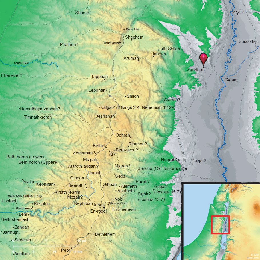
Fig. 1. Map of ancient Palestine. The Plain of Jordan probably included the valley floor from the Sea of Galilee to south of the Dead Sea (Biblos 2010).
The Bible identifies the Plain of Jordan as the region between Succoth and Zarthan north of Jericho (1 Kings 7:46). This entire area from the Sea of Galilee in the north to the south end of the Dead Sea is described as well-watered, like a garden, as far south as Zoar. Zoar was one of the five cities of the plain (Sodom, Gomorrah, Admah, Zeboiim, and Zoar). Bryant Wood (2008), editor of Bible and Spade, believes the five cities of the plain were located on the southeastern shore of the Dead Sea. It is also likely that the higher terrain outside the Plain of Jordan would have been even more fertile, because the hills would have been cooler and received more rainfall due to orographic effects like today.
This description of a moist, fertile landscape in Abraham’s age is in stark contrast to the dry desert environment of the Jordan Valley which exits today. Only near springs along the riparian boundary of the Jordan where modern irrigation is practiced are any trees and green vegetation evident. The rainfall south of the Sea of Galilee is so sparse that practically no vegetation of any kind is possible without irrigation in this hot, desert environment. Yet, even as late as 1,000 years after the Flood (~1500 BC), about the time the Israelites escaped from Egypt and were about to enter the Promised Land, Palestine was described as “. . . a land flowing with milk and honey . . .” (Exodus 33:3).
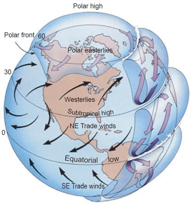
Fig. 2. Global atmospheric circulation. Note: Northeast tradewinds between the equator and 30°N latitude and westerlies between 30°N and 60°N latitude. Descending air near 30°N produces high pressure and hot, dry conditions. View larger image.
Today the entire Middle East is a desert throughout North Africa, Israel, Jordan, Syria, Iraq, Iran, and Saudi Arabia. This dry zone extends around the entire hemisphere centered at 30° latitude. It is primarily due to descending air in the subtropics between an atmospheric circulation cell near the equator and the westerlies at mid-latitudes centered at about 45°. Fig. 2 shows the three-dimensional global atmospheric circulation of earth at present over North America. Similar conditions prevail over the Middle East.
In addition to the biblical hints of a wetter climate in Israel during the time of Abraham, paleoclimatological evidence also indicates that the entire Middle East experienced more precipitation, had more vegetation, and the lakes were fuller in the past. Crowley and North (1991) have shown that the jet stream in North America was positioned much farther south over North America during the ice age and storms in the westerly flow produced more rain and snow at more southerly latitudes. The winter storm track was thought to have traveled across central California to the mid-Atlantic States rather than along the upper tier of states like today.
The same effect would have likely occurred over Europe and western Asia causing a storm track across the Mediterranean, Iraq, and Iran rather than over central Europe and northern Turkey. The storm track, which is typically north of the Himalayas today, may have been positioned to the south. Such a storm track would have produced more rain in North Africa, Egypt, Israel, Jordan, Syria, Iran, Iraq, Afghanistan, Pakistan, and northern India. In addition, the monsoon which migrates north and south over India and southeast Asia today may have been more intense immediately after the ice age because of the greater temperature contrast between the Tibetan Plateau and the Indian Ocean. The heavy summer precipitation of the monsoon is caused by heating and rising of warm air over the Tibetan Plateau and pulling of moist air northward from the Indian and western Pacific Oceans onto the rising terrain of the Himalayas. In winter cold air drains from the Tibetan Plateau reversing the flow toward the oceans producing dry conditions. For many years after the ice age the Indian Ocean was probably much warmer than today, for reasons to be described below, disrupting this annual monsoonal oscillation. It is likely that rain fell more heavily all year round in southern Pakistan, India, and southeast Asia.
Bradley (1985) has provided evidence for higher lake levels in North Africa and the Middle East 6,000 years ago. Great herds of large animals are believed to have roamed over large grasslands of north Africa similar to east Africa today. Some of this conjecture is based on petroglyphs of wild animals on stone outcrops in the deserts of north Africa. Estimates of greater precipitation is based on higher lake levels and climate simulations. Thirgood (1981) and Meiggs (1982) provide detailed discussions of the widespread forests which were once present around the Mediterranean basin and offer arguments for various theories for their depletion. The primary theories given for the decline in forests are drought, timbering, grazing, and geological change. We believe the strongest arguments support climate change.
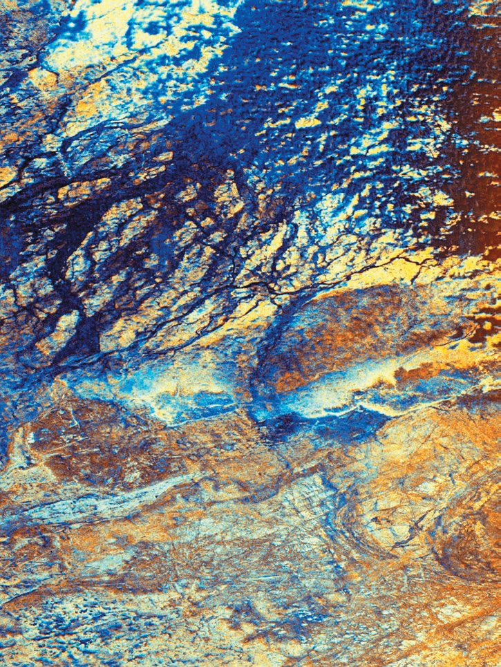
Fig. 3. False-color image from the Synthetic Aperture Radar (SAR) onboard the NASA (1994) space shuttle Endeavour. The image is of the uninhabited Safsaf Oasis in southern Egypt. The big valley and the channels in it are not visible on the ground and in optical photographs. The valley is hypothesized to have been carved by ancient rivers.
NASA (1994) has published pictures (see fig. 3) of downward-looking radars from space craft which can peer through tens of feet of sand in the deserts to reveal river beds which are believed were once formed by ancient rivers. Such rivers do not exist today, implying that much greater amounts of rain must have fallen in the past. In addition to these conventional explanations for past greater rainfall over the Middle East is a new theory from this research that hypercyclones likely formed over the Indian Ocean and the Arabian Sea transporting large amounts of moisture over what are now desert regions to greatly increase the rainfall.
In the 1960s images of seafloor topography were first published showing a mid-ocean ridge on the bottom of the ocean which extends completely around the earth. Fig. 4 shows this mid-ocean ridge which is about 65,000 km (40,000 miles) long, up to 1.83 km (6,000 feet) high relative to the ocean floor, and, in places, several hundred kilometers (miles) wide. It is composed of lava and magma which were ejected from the earth’s mantle onto the ocean floor between tectonic plates at temperatures over 500°C (900°F). The catastrophic plate tectonics model (Austin et al. 1994) proposes that the mid-ocean ridge is the result of cooled lava and magma formed in only a few years during and immediately following the Flood. The conventional view is that the molten rock was ejected over millions of years, warming the ocean only slightly. However, if the Genesis Flood occurred only a few thousand years ago, the heat would have been released from the mid-ocean ridges in a much shorter time, causing the oceans to warm dramatically. The average ocean temperatures derived from foraminifera in sea-floor sediments show that the oceans were indeed much warmer (as much as 35°C [95°F]) during the Cretaceous Period (Austin et al. 1994). Warmer oceans would have resulted in warm sea-surface temperatures following the Flood.
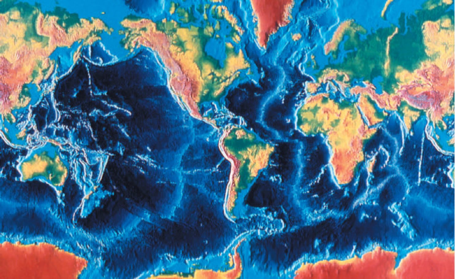
Fig. 4. Sea-floor topography derived from sonar depth measurements. The light blue linear features are the mid-ocean ridges. Note particularly the spur which runs from southeast of Africa into the Indian Ocean and the Arabian Sea (Heezen and Tharp 1977).
Gray (1968) and Emanuel (1987) have shown that a sea-surface temperature warmer than 26.5°C (80°F) is one of the conditions for the formation of hurricanes. Emanuel (1991) extended the theory of hurricane development for sea-surface temperatures warmer than those presently observed on earth and predicted the development of massive hurricanes he coined as hypercanes. Vardiman (2003) and Zavacky (2002) applied these ideas to an actual hurricane by simulating the development of Florence, a modest hurricane in the Gulf of Mexico, for sea-surface temperatures as warm as 45°C (113°F). The result was a hypercane with horizontal and vertical winds twice as fast and precipitation rates ten times greater than the actual storm.
Because precipitation in the Middle East appears to have been greater for many years following the Genesis Flood and a spur of the mid-ocean ridge present in the Arabian Sea may have simultaneously increased cyclone development, it was decided to attempt to simulate some recent cyclones in the Arabian Sea at warmer sea-surface temperatures and evaluate their effect on rainfall. The computer model used to simulate the cyclones was the Weather Research and Forecasting (WRF) model (NCAR, 2007). The tropical cyclone reported for this simulation was Cyclone Gonu (Gonu 2007).
Circulation in Hurricanes and Cyclones
Hurricanes and cyclones are tropical systems which transform heat energy released from a warm ocean to kinetic energy of rotation. They function as very efficient heat engines operating by the temperature difference between a warm heat reservoir at the sea surface and a cold heat reservoir in the stratosphere. Emanuel (1991) at the Massachusetts Institute of Technology published several papers reporting on this engineering approach to energy conversion in hurricanes. A portion of the heat energy comes from the transfer of heat energy from the sea surface, but a larger amount comes from the condensation of water vapor drawn from the lower atmosphere and the release of latent heat.
In the northern hemisphere air spirals in a counter-clockwise direction toward the low-pressure center of a hurricane. It decreases in radius to the point at which the inward pressure-gradient forces are balanced by the outward centrifugal forces of rotation. Fig. 5 shows how this air then rises upward in the eyewall and flows outward aloft in a clockwise rotation. The highest horizontal and vertical winds, turbulence, and precipitation occur in this eyewall. The airflow in the stratosphere aloft is cold and relatively dry with cirrus clouds. Satellite and radar images show that the airflow is counter-clockwise at low levels and clockwise aloft.
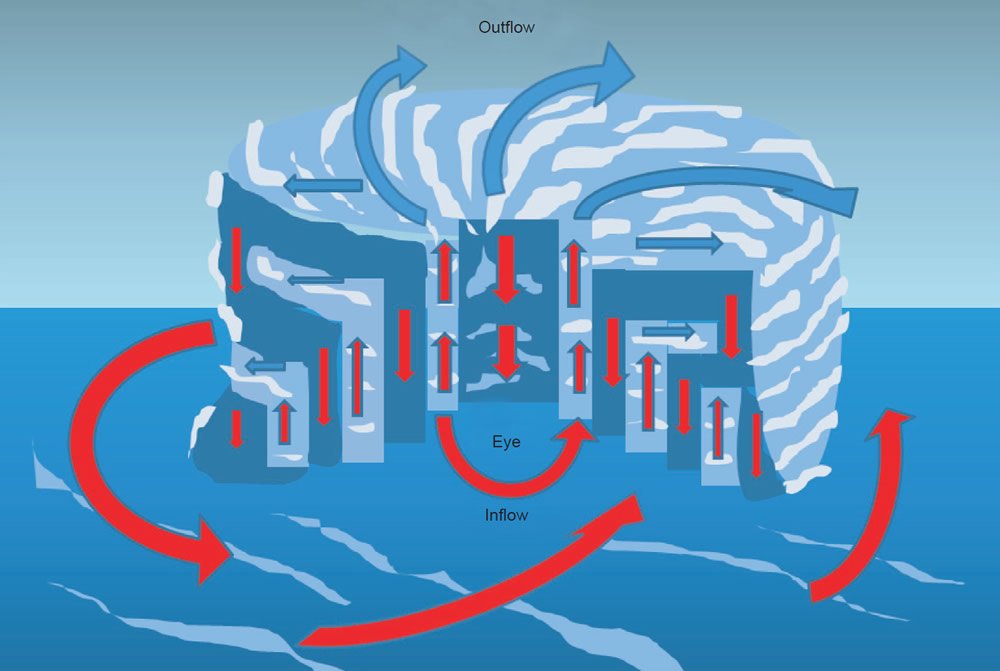
Fig. 5. Circulation in and around a hurricane or tropical cyclone. In the Northern Hemisphere warm moist air flows counter-clockwise into a hurricane at the surface, upward in the eyewall, and clockwise outward as cold, dry air aloft.
Previous Simulations of Hurricanes over Hot Sea-Surface Temperatures
Vardiman (Austin et al. 1994) realized that if the Genesis Flood released large quantities of heat by catastrophic processes and produced hot sea-surface temperatures, as first proposed by Oard (1990), more intense and numerous hurricanes would have occurred after the Flood for many years. Zavacky (2002) and Vardiman (2003) simulated a weak hurricane—Hurricane Florence—which occurred in the Gulf of Mexico in 1988 with a numerical NCAR mesoscale weather model called MM5 (NCAR 2003), the predecessor to the Weather Research and Forecasting model (WRF) (NCAR 2007). The actual hurricane maintained a steady-state intensity over a moderately warm sea-surface temperature for about 36 hours as it tracked slowly northward towards New Orleans. When sea-surface temperature was increased to 45°C (113°F) the simulated hurricane grew into a gigantic hypercane filling the Gulf of Mexico, doubling the horizontal and vertical winds, and increasing the precipitation by a factor of ten.
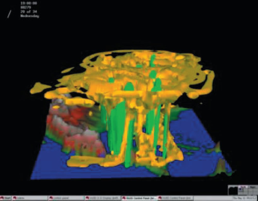
Fig. 6. A simulation of Hypercane Florence at 20 hours after increasing the sea-surface temperature in the Gulf of Mexico. Yellow is cloud boundary and green is precipitation (Vardiman 2003).
Fig. 6 shows simulated Hypercane Florence 20 hours after sea-surface temperature was increased from 30°C (86°F) to 45°C (113°F). The yellow region is the cloud boundary and the green is precipitation. Note that the horizontal winds rotated counterclockwise so fast near the bottom of the storm that the cloud and precipitation towers leaned downwind with altitude. The cirrus anvil at the top of the storm grew dramatically in size and covered not only the Gulf of Mexico but most of the eastern United States. Hypercane Florence far exceeded a category 5 hurricane at the end of the simulation. Such an intense and massive storm is not observed today, but likely occurred under conditions following the Genesis Flood.
Zavacky (2002) conducted a more complete analysis on the simulation of Hurricane Florence at various sea-surface temperatures and determined that horizontal wind speed, pressure drop in the eye, and accumulated precipitation all depend on a highly non-linear relationship with sea-surface temperature. She also determined that the maximum wind speed could become as fast as 643 kph (400 mph)—over twice the wind speed of category 5 hurricanes today. Winds of this speed would be expected to produce four times the damage of category 5 hurricanes because of the quadratic relationship between wind speed and the force on objects. Such storms would destroy almost all trees and structures on land surfaces. In addition, hypercanes would produce ten times the precipitation of category 5 storms as well as huge storm surges and flooding. All of these effects would be incredibly destructive.
Tropical Cyclone Gonu
Gonu is the strongest tropical cyclone on record in the Arabian Sea, and is also the strongest named cyclone in the northern Indian Ocean. Gonu developed from a persistent area of convection in the eastern Arabian Sea on June 1, 2007. With a favorable upper-level environment and warm sea-surface temperatures, it rapidly intensified to attain peak winds of 240 kph (150 mph) on June 3. Fig. 7 displays the sea-surface temperature during the period of the storm. Gonu weakened after encountering dry air and cooler water near the coastline of Saudi Arabia and early on June 6 made landfall on the eastern-most tip of Oman. It then turned northward into the Gulf of Oman, and dissipated on June 7 after crossing the Gulf of Oman and making landfall in southern Iran.
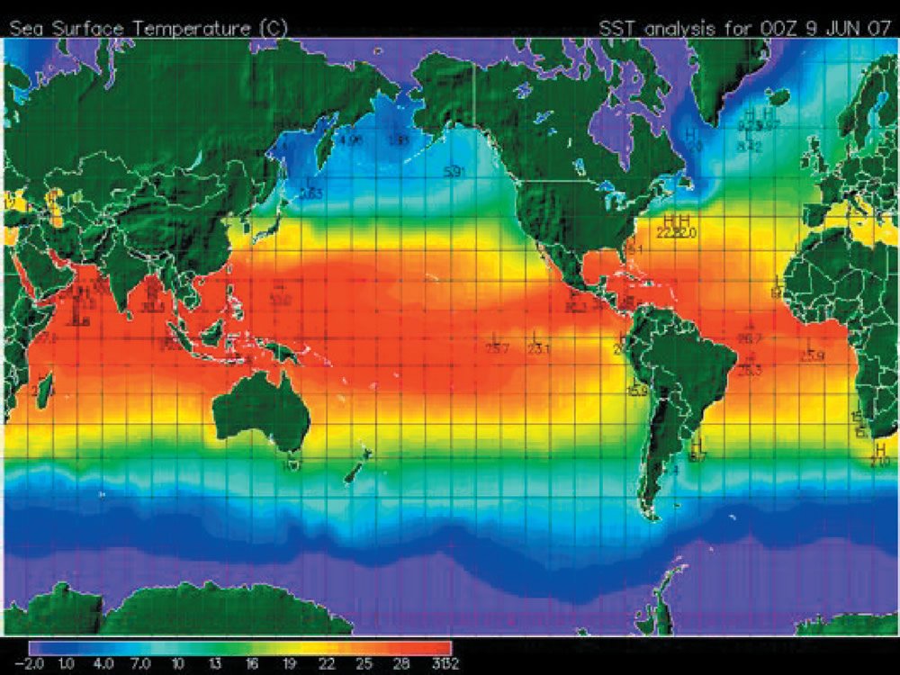
Fig. 7. Sea-surface temperature over entire globe. Notice the temperature in the Arabian Sea was approximately 30°C (86°F) (NASA 2007a).
Intense tropical cyclones like Gonu are extremely rare over the Arabian Sea presently, since most storms in this area tend to be small and dissipate quickly. The cyclone caused 50 deaths and about $4.2 billion in damage (2007 USD) in Oman, where the cyclone was considered the nation’s worst-ever natural disaster. Gonu dropped heavy rainfall near the eastern coastline, reaching up to 610 mm (24 in.), which caused flooding and heavy damage. In Iran, the cyclone caused 28 deaths and $216 million in damage (2007 USD).
Toward the end of May, 2007, the monsoon trough spawned a low pressure area in the eastern Arabian Sea. By May 31, an organized tropical disturbance was located about 645 km (400 miles) south of Mumbai, India, with cyclonic convection, thunderstorm activity, and a well-defined mid-level circulation. The disturbance initially lacked a distinct low-level circulation; instead it consisted of strong divergence along the western end of a surface trough of low pressure. A favorable upper-level environment allowed convection to improve, and by late on June 1, the system developed to the extent that the India Meteorological Department (IMD) classified it as a depression. It tracked westward along the southwestern periphery of a mid-level ridge over southern India. Convection continued to organize, and early on June 2 the Joint Typhoon Warning Center (JTWC) classified it as a tropical cyclone about 685 km (425 miles) southwest of Mumbai.
Upon first forming, the system contended with the entrainment of dry air to the northwest of the storm, which was expected to limit intensification. But, the storm steadily intensified, and early on June 2 the IMD upgraded it to deep depression status. Later in the day the IMD classified the system as Cyclonic Storm Gonu about 760 km (470 miles) southwest of Mumbai, India. As a mid-latitude trough developed over Pakistan, Gonu turned to the north and northeast, though it resumed a westward track after ridging built to the north of the storm. With a solid area of intense convection, it rapidly intensified to attain severe cyclonic status early on June 3, and with good outflow the JTWC upgraded it to the equivalent of a minimal hurricane. The dry air ultimately had a smaller impact on the intensification than previously estimated. A well-defined eye developed in the center of convection. After moving over a locally warm regions of the ocean, Gonu rapidly deepened.
Late on June 3, the IMD upgraded the storm to Very Severe Cyclonic Storm Gonu. With low amounts of vertical wind shear and favorable upper-level outflow, Gonu strengthened further to attain peak 1-minute sustained winds of 270 kph (165 mph) and gusts to 315 kph (195 mph), about 285 km (175 miles) east-southeast of Masirah Island on the coast of Oman. The IMD upgraded it to Super Cyclonic Storm Gonu late on June 4, with peak 3-minute sustained winds reaching 240 kph (150 mph) and an estimated pressure of 920 mb. See Fig. 8 for a satellite image of Tropical Cyclone Gonu off the coast of Oman.
After the storm maintained peak winds for about six hours, the IMD downgraded Gonu to a very severe cyclonic storm late on June 4. Its eye became cloud-filled and ragged, and the cyclone gradually weakened due to cooler water temperatures and drier air as it approached the Arabian Peninsula. Due to land interaction with Oman, the inner core of deep convection rapidly weakened, and over a period of 24 hours the intensity decreased by 95 kph (60 mph). According to the IMD, Cyclone Gonu crossed the eastern-most tip of Oman still as a very severe cyclonic storm early on June 6. Although the winds continued to gradually decrease, overall organization increased slightly in the hours prior to landfall; Gonu maintained a well-defined low-level structure with a weak eye.
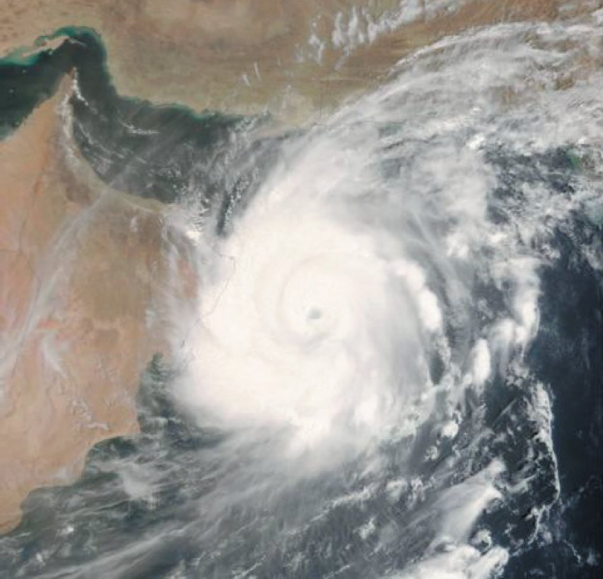
Fig. 8. NASA image of Tropical Cyclone Gonu off the coast of Oman on June 4, 2007 (NASA 2007b).
After emerging into the Gulf of Oman, the cyclone briefly re-intensified slightly. However, increasing wind shear and entrainment of dry air from the Arabian Peninsula continued to remove deep convection from its eastern semicircle. On June 6, the cyclone turned to the north-northwest, and later that day the JTWC downgraded Gonu to tropical storm status. The IMD followed suit by downgrading Gonu to severe cyclonic storm status and later to cyclonic storm status early on June 7. Gonu crossed the Makran coast in Iran six hours later and the IMD stopped issuing advisories on the cyclone. The path of Tropical Cyclone Gonu during its lifetime is shown in Fig. 9.
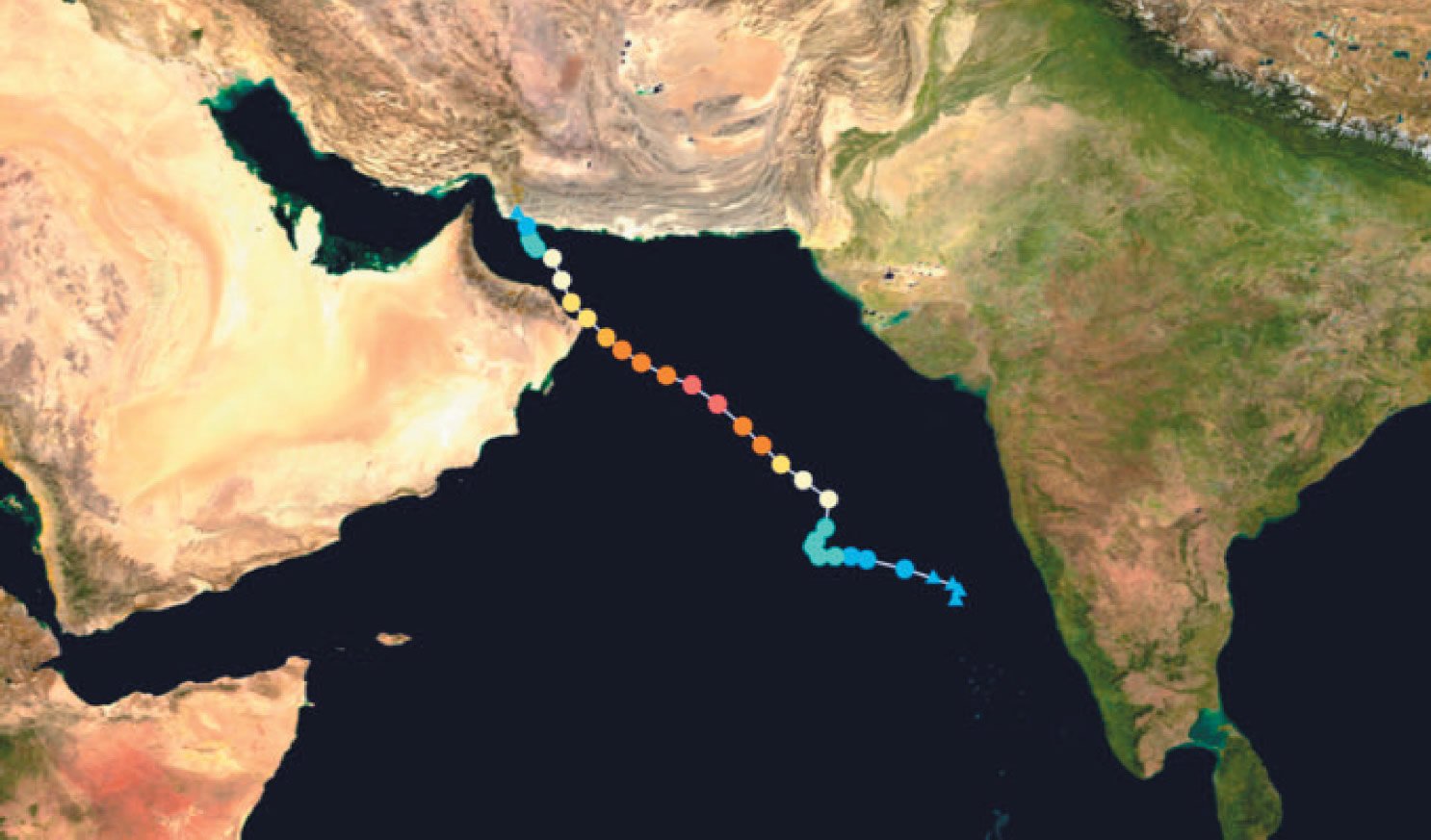
Fig. 9. Track of Tropical Cyclone Gonu from June 1–7, 2007 (Wikipedia 2007a).
Gonu produced an unprecedented amount of precipitation as it passed the coast of Oman. Fig. 10 shows the accumulated precipitation from May 31 through June 7, 2007 in the vicinity of Oman. Note that the general area-wide precipitation exceeded 250 mm (10 inches) of rainfall over much of Gonu’s track and exceeded 600 mm (24 inches) on the east coast of Oman.
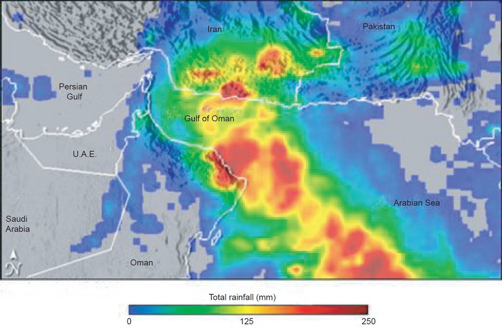
Fig. 10. Accumulated precipitation from Tropical Cyclone Gonu near Oman from May 31–June 7, 2007 (Wikipedia 2007b).
Numerical Simulation of Gonu
We selected the same numerical model that Vardiman and Brewer (2010a, 2010b, 2010c) used to simulate winter storms in Yosemite and Yellowstone National Parks. The NCAR Weather Research and Forecasting model (NCAR 2007) is a mesoscale model which computes wind, humidity, precipitation, and many other variables over a three-dimensional grid at any location and resolution on earth. Al-Katheri, Radi, and Dhanhani (2008) of the United Arab Emirates Air Force and Air Defense Command used WRF to simulate Gonu for the observed sea-surface temperatures. Their purpose was to assess the accuracy of WRF in simulating the storm track and pressure fields of Gonu in order to use the model as a standard forecast tool for future cyclones in the Arabian Sea.
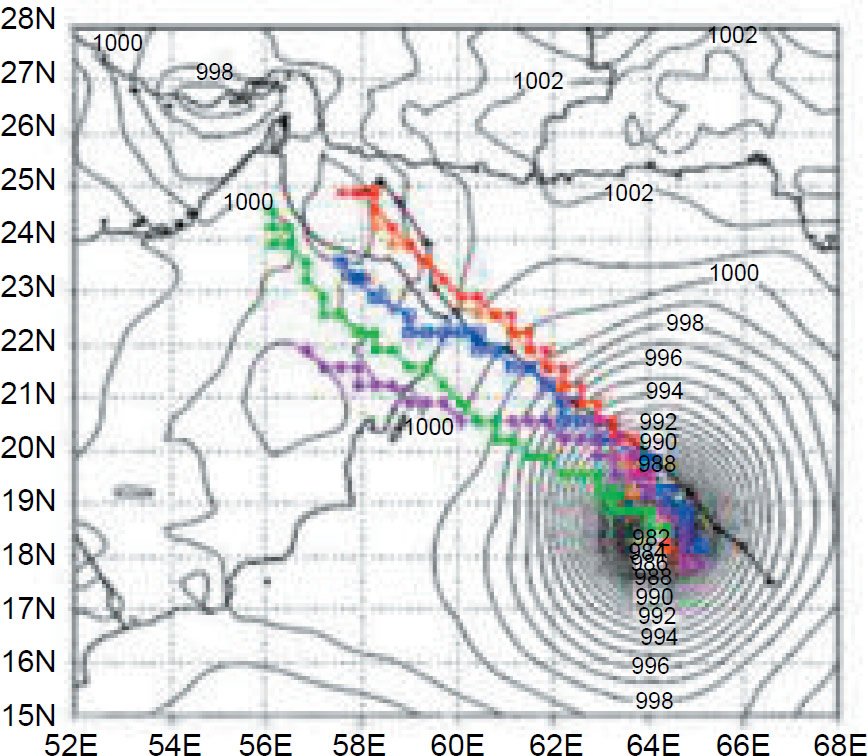
Fig. 11. Cyclone Gonu track forecasts issued for 00Z on June 4 (00Z is midnight at Greenwich, England). The actual cyclone track is in black, and the red, blue, green, purple, and orange runs are for other various model conditions. The isobars in the background were analyzed for the orange run on June 4 at 00Z (after Al-Katheri, Radi, and Dhanhani 2008).
Fig. 11 shows an example of the track forecasts Al-Katheri, Radi, and Dhanhani (2008) obtained from five model runs compared to the actual storm track. The five runs incorporated data and error variances into the WRF model in different ways. For example, the orange run used the whole set of available observations, error tuning factors, so-called warm cycling, scaling factors for the three outer loops (domains) selected, and adjustments for non-linearity. The other runs used different statistical applications. They concluded that the orange run predicted the best storm track, minimum pressure, and wind speed. They concluded that they had successfully simulated the cyclone and decided to include WRF simulations in their operational suite of forecasts.
We used a similar approach in selecting nested domains over Saudi Arabia and running the model. However, our emphasis was on the wind and moisture fields at hotter sea-surface temperatures than observed. Another difference was that Al-Katheri, Radi, and Dhanhani (2008) assimilated unconventional wind, satellite, and radar data from several independent observing systems in and around the Persian Gulf, in addition to data from the Research Data Archive (RDA) available through NCAR.
We chose to locate a rectangular computational domain over a point in the center of Saudi Arabia at 25°N latitude and 45°E longitude. Because the moisture and wind fields around the tropical cyclones modeled by WRF migrated over relatively long distances, and we wished to observe the wind, humidity, and precipitation fields over the entire Middle East, we displayed the results for a domain extending from the center of the Arabian Sea in the southeast, to the Mediterranean Sea in the northwest, and from north central Africa in the southwest, to the Himalayas in the northeast. The domain was 5,670 km (3,523 miles) east/west and 4,320 km (2,684 miles) north/south. Computations were performed using a computational grid with 210 cells east/west and 160 cells north/south, each 27 km (16.8 miles) on a side.
Fig. 12 shows the domain over the Middle East with the topography and coastlines. Note that the highest terrain extended from the Himalayas southwestward through Afghanistan, Iran, and Turkey. Moderate terrain occurred near Oman, on the western shore of Saudi Arabia, southwestern Egypt, and in eastern Sudan and Ethiopia. Whenever a cyclone makes landfall or strong, moist winds interact with mountainous terrain, orographic clouds and heavy rainfall occur.
The meteorological data used in this study for June 2–20, 2007 were obtained from the Research Data Archive (RDA) maintained by the computational and Information Systems Laboratory (CISL) at the National Center for Atmospheric Research (NCAR). These data included the general atmospheric conditions which formed and maintained cyclone Gonu. Sea-surface temperatures of 40°C (104°F) were prescribed for all water surfaces shown in Fig. 12 including the Indian Ocean, the Arabian Sea, the Red Sea, the Persian Gulf, and the Mediterranean Ocean.
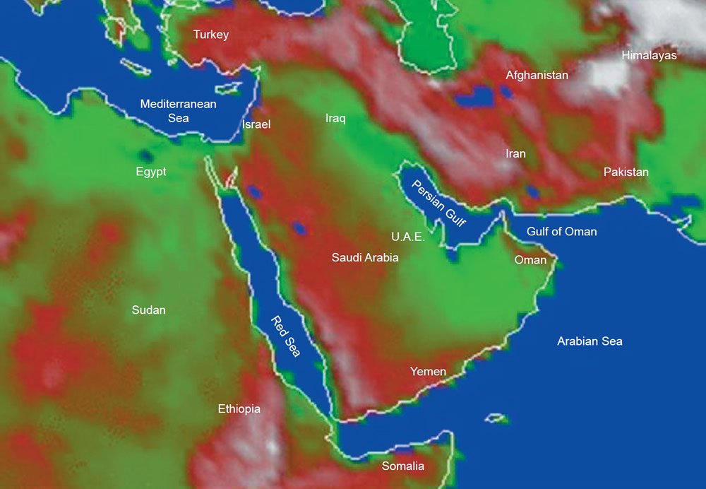
Fig. 12. Computational domain for hypercyclone Gonu in the Arabian Sea centered on 25°N and 45°E in central Saudi Arabia.
We believe hot sea-surface temperatures are appropriate for all water surfaces in this simulation because the mid-ocean ridge or other sub-marine heat sources were in contact with all water bodies surrounding Saudi Arabia. This includes the eastern Mediterranean which also contains evidence for catastrophic tectonic upheavals.
Results
Wind fields, humidity, and precipitation were calculated for Cyclone Gonu using actual sea-surface temperatures and also for hypercyclone Gonu with a sea-surface temperature of 40°C (104°F) on June 2–20, 2007. The simulation of Cyclone Gonu for actual sea-surface temperatures closely matched the observations of path, intensity, and precipitation for actual Cyclone Gonu. The wind fields, humidity, and precipitation were greatly enhanced for hypercyclone Gonu and the path extended much farther into Iran.
Low-level wind fields
The horizontal wind at 5 km (~16,400 ft) altitude above mean sea level (msl) for hypercyclone Gonu is shown in Figs. 13–20. Displays are given only for June 3–6 and June 17–20 in order to save space since the fields did not change significantly during the intermediate period. Hypercyclone Gonu entered the Arabian Sea from the lower right-hand corner of the domain and traveled northwestward off the tip of Oman near Muscat as it intensified. The winds circling the eye exceeded 65 m/s (~145 mph) before it made landfall in Oman. It then crossed the Gulf of Oman and made a second landfall in Iran west of the Pakistan border, similar to the actual cyclone.
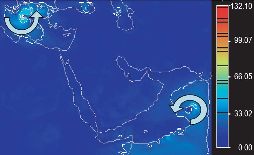
Fig. 13. Wind speed at 5 km (~16,400 ft) altitude at 00Z on Sunday, June 3. Scale is in m/s and contours at intervals of 20 m/s.
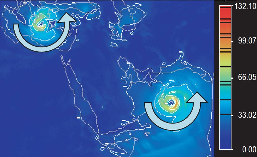
Fig. 14. Wind speed at 5 km (~16,400 ft) altitude at 00Z on Monday, June 4. Scale is in m/s and contours at intervals of 20 m/s.
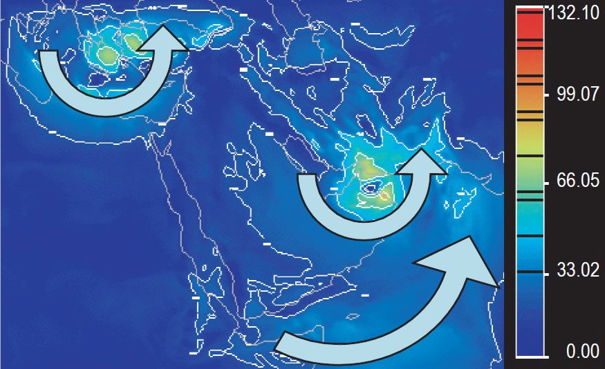
Fig. 15. Wind speed at 5 km (~16,400 ft) altitude at 00Z on Tuesday, June 5. Scale is in m/s and contours at intervals of 20 m/s.
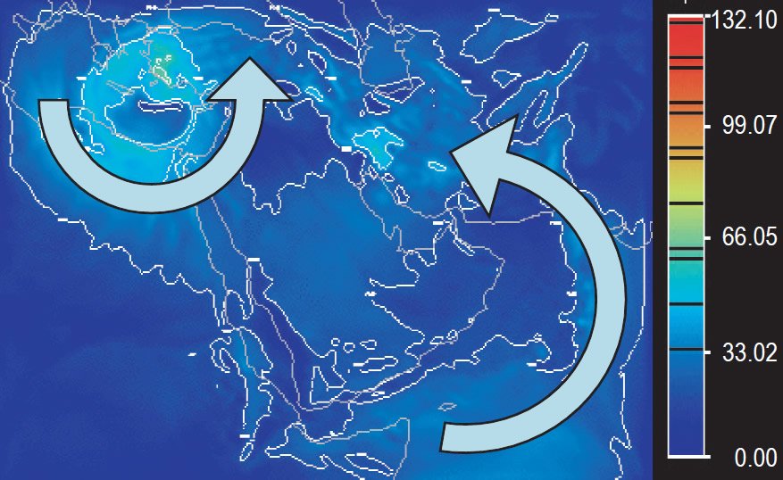
Fig. 16. Wind speed at 5 km (~16,400 ft) altitude at 00Z on Wednesday, June 6. Scale is in m/s and contours at intervals of 20 m/s.
Fig. 14 shows the most fully-developed stage of the hypercyclone before it made the first landfall in Oman. Green regions contained winds of over 65 m/s (~145 mph), yellow regions 75m/s (~167 mph), and orange regions 90 m/s (~200 mph). The horizontal winds around the eye of hypercyclone Gonu were about 50% faster than the actual cyclone Gonu’s speed of 60 m/s (~134 mph) when it made landfall. Damage in hypercyclone Gonu would have been over 125% greater than the actual cyclone because wind damage is proportional to the speed of the wind squared. The eye was much larger and the diameter of the high-speed winds greater yet. The high-speed winds of hypercyclone Gonu could be tracked over the coastal mountains into northern Iran. Actual cyclone Gonu could not be tracked beyond the coastal range.
After the closed circulation of hypercyclone Gonu entered Iran from the Gulf of Oman, the hot sea-surface temperatures established a large-scale, counter-clockwise circulation at low altitudes over the entire Middle East centered on Saudi Arabia. A low-level jet of high-speed winds of about 65 m/s (~145 mph) flowed southward over Egypt, eastward across the Gulf of Aden, and northeastward through the Arabian Sea into Pakistan, Afghanistan, and Iran. Closed circulations and other disturbances flowed southward from the Mediterranean Sea into Egypt in the western portion of this large-scale circulation. Notice especially the closed circulation that moved from the Mediterranean Sea over Egypt and the Sudan in Figs. 17–20. Disturbances also traveled into Iran along the northward flow in the eastern portion of the circulation.
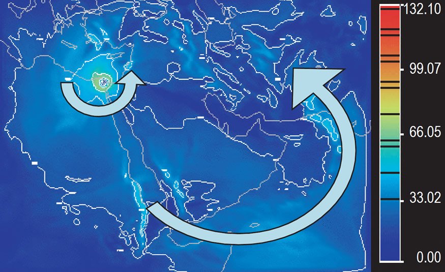
Fig. 17. Wind speed at 5 km (~16,400 ft) altitude at 00Z on Sunday, June 17. Scale is in m/s and contours at intervals of 20 m/s.
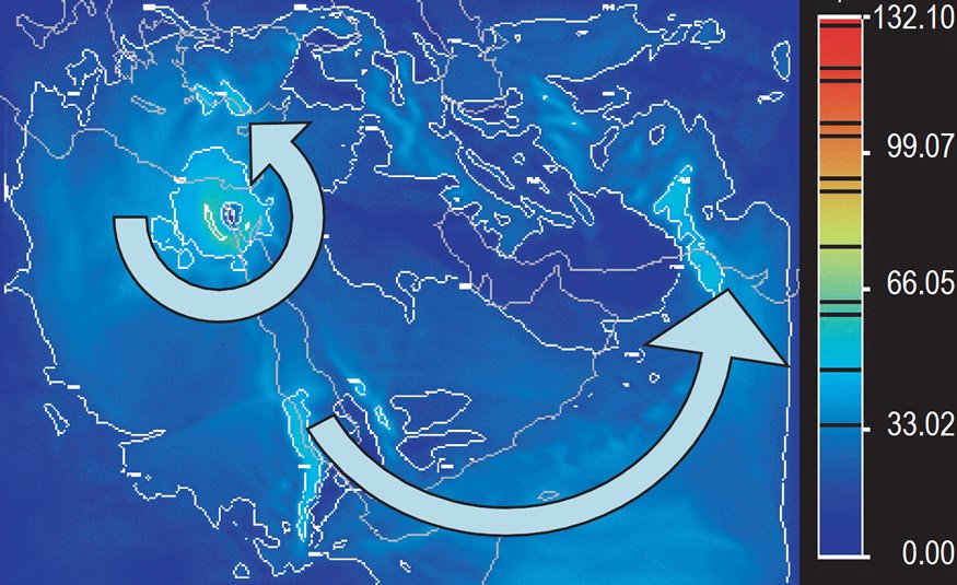
Fig. 18. Wind speed at 5 km (~16,400 ft) altitude at 00Z on Monday, June 18. Scale is in m/s and contours at intervals of 20 m/s.
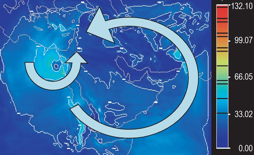
Fig. 19. Wind speed at 5 km (~16,400 ft) altitude at 00Z on Tuesday, June 19. Scale is in m/s and contours at intervals of 20 m/s.
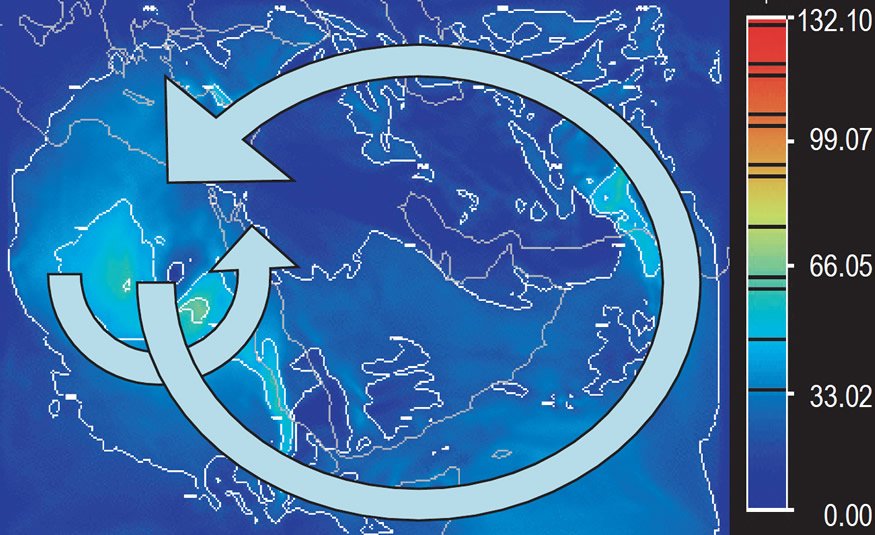
Fig. 20. Wind speed at 5 km (~16,400 ft) altitude at 00Z on Wednesday, June 20. Scale is in m/s and contours at intervals of 20 m/s.
The large-scale circulation over the Middle East in this simulation is thought to be due to the general heating from all the hot water surfaces surrounding Saudi Arabia. Smaller-scale circulations like the one which moved from the eastern Mediterranean southward over Egypt are due to localized organization of storms. It is also likely that short waves moving along the jet stream to the north can ride around the larger circulation pattern over Saudi Arabia moving farther south and creating storms over the deserts of the Middle East. We believe the large-scale or small-scale circulations are real effects of hot sea-surface temperatures and are not due to boundary conditions or instabilities in the model.
The large-scale circulation covering the Middle East in this simulation is not observed today. We believe it was caused by the hot sea-surface temperatures over the Arabian Sea and was probably responsible for transporting water vapor and precipitation into the desert regions of the Middle East for up to 1,000 years or more after the Flood. This could be the explanation for greater vegetation in these regions in the past.
Hypercane GONU Wind Speeds at 5 km (16,400 ft)
High-level wind fields
The horizontal wind at 25 km (~82,000 ft) mean sea level is shown in Figs. 21–28 for the same time period as the wind speed at 5 km (~16,400 ft) in Figs. 13–20. The clockwise circulation shown in most of the images in this sequence is due to the outflow of air rising upward and outward from the cyclone below. The air moves outward at the top of the hypercyclone due to the conservation of mass in the stable environment of the stratosphere. As the air flows away from the center of the circulation, it reacts to the Coriolis force and turns in a clockwise direction in the northern hemisphere. The circulation pattern expands and moves in response to the growing circulation near the surface.
Fig. 21 shows the airflow from west to east across the Middle East in a high-altitude jet stream before the cyclone at the surface begins to grow into a hypercyclone. Fig. 22 shows the initial development of the clockwise circulation aloft 24 hours later as the hypercyclone begins to develop over the Arabian Sea. Fig. 23 shows the massive growth of the upper-level clockwise circulation as the hypercyclone grows. By this time the upper-level circulation has covered most of the Arabian Sea and has expanded into Turkey to the north and into Egypt to the west. The wind speed in red exceeds 130 m/s (~290 mph). The wind spirals upward and outward as the air ascends from the surface to 25 km (15 miles). The source of the upward motion is the hypercyclone Gonu and the warm Arabian Sea.
Figs. 23 shows the upper-level clockwise circulation continuing to expand to cover the entire Middle East. The wind speed decreased as the circulation increased in size and a secondary circulation occurred within the larger field, due to a cyclone which formed over the Mediterranean Sea. The larger circulation is produced by the general upward flow of air from the entire Arabian Sea while the smaller circulation is due to the upward flow from hypercyclone Gonu. Once the hypercyclone moved over Iran it eventually dissipated and this inner circulation ceased.
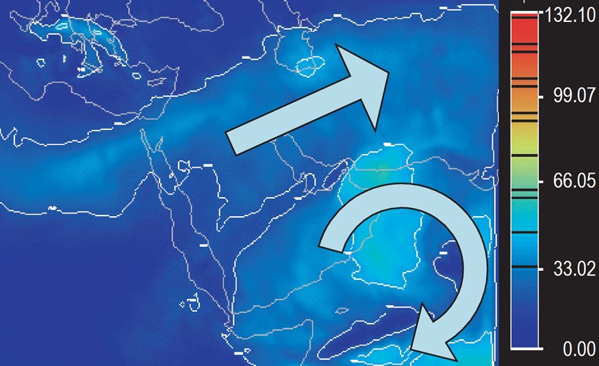
Fig. 21. Wind speed at 25 km (~82,000 ft) altitude at 00Z on Sunday, June 3. Scale is in m/sec and contours at intervals of 20 m/sec.
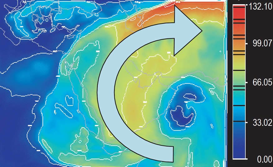
Fig. 22. Wind speed at 25 km (~82,000 ft) altitude at 00Z on Monday, June 4. Scale is in m/s and contours at intervals of 20 m/s.
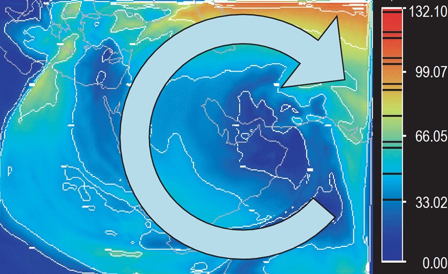
Fig. 23. Wind speed at 25 km (~82,000 ft) altitude at 00Z on Tuesday, June 5. Scale is in m/s and contours at intervals of 20 m/s.
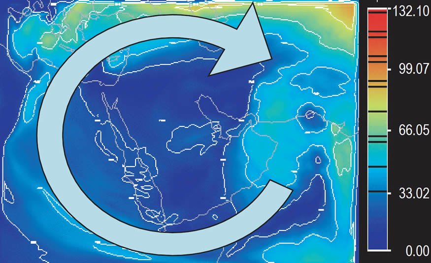
Fig. 24. Wind speed at 25 km (~82,000 ft) altitude at 00Z on Wednesday, June 6. Scale is in m/s and contours at intervals of 20 m/s.
Figs. 25–28 show the large-scale clockwise circulation from rising air over the Arabian Sea later in the simulation. It weakens with time, but maintains a clockwise pattern which covers the entire Middle East. This clockwise circulation covers a circular area with a diameter of over 5,000 km (~3,000 miles). Embedded within this large circulation are smaller clockwise circulations produced by closed counter-clockwise circulations at the surface which pump air upward. These small, clockwise circulations aloft follow the source of air rising from below, similar to the pattern described earlier at the surface for hypercyclone Gonu. For example, a small circulation is apparent near Cairo, Egypt in Fig. 25. In Figs. 26– 28 it grows in size and intensity and moves southward across Egypt. It tracks the counter-clockwise circulation at the surface first seen in Figs. 21–24. The clockwise airflow aloft is fed by the counter-clockwise flow near the surface.
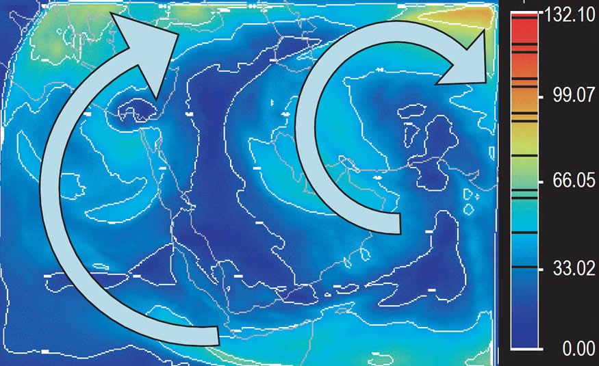
Fig. 25. Wind speed at 25 km (~82,000 ft) altitude at 00Z on Sunday, June 17. Scale is in m/s and contours at intervals of 20 m/s.
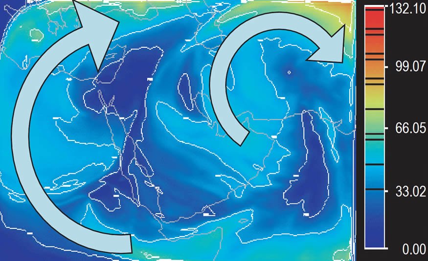
Fig. 26. Wind speed at 25 km (~82,000 ft) altitude at 00Z on Monday, June 18. Scale is in m/s and contours at intervals of 20 m/s.
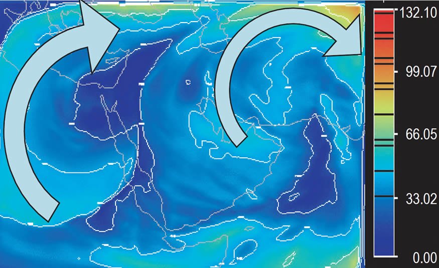
Fig. 27. Wind speed at 25 km (~82,000 ft) altitude at 00Z on Tuesday, June 19. Scale is in m/s and contours at intervals of 20 m/s.
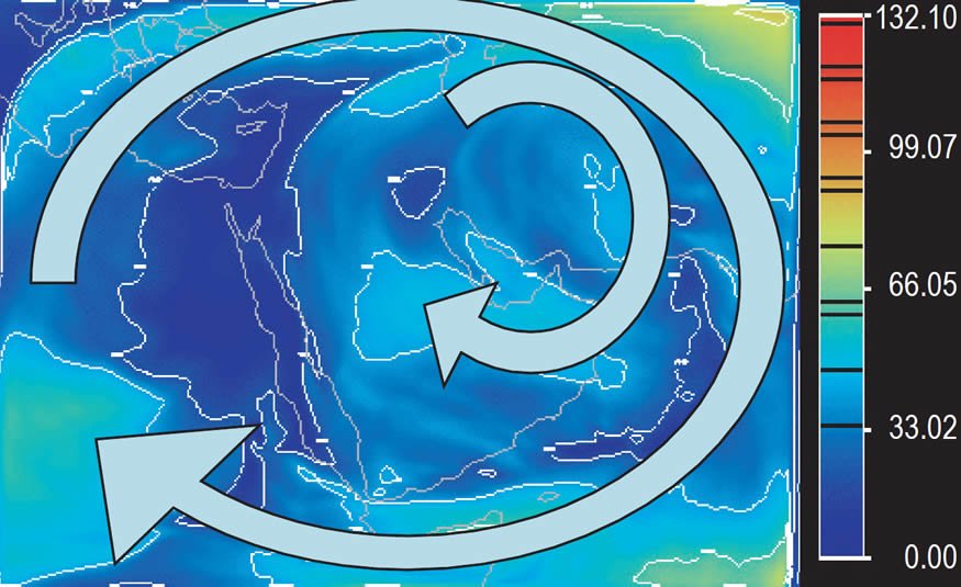
Fig. 28. Wind speed at 25 km (~82,000 ft) altitude at 00Z on Wednesday, June 20. Scale is in m/s and contours at intervals of 20 m/s.
Moisture, clouds, and precipitation are associated with these closed circulations and produce rain in what are deserts today. The large-scale circulation patterns which drive the smaller-scale circulations vary and produce rain over different regions.
Hypercane GONU Wind Speeds at 25 km (~82,000 ft)
Moisture
Figs. 29–36 show the relative humidity at 15 km (~49,200 ft) for the same time period as the previous wind-speed plots. A mid-level in the simulation was chosen to show the typical distribution of high relative humidity (red) and low relative humidity (blue) for hypercyclone Gonu. At surface levels and above the tropopause high humidity is widespread and the transport of humidity is difficult to visualize. This is also the level which supplies much of the moisture for precipitation to the surface.
Figs. 29–32 show the development of the moisture shield around hypercyclone Gonu as it formed in the Arabian Sea in the lower right-hand corner of the domain and moved northwestward toward Oman. In Figs. 31–32 the circulation of hypercyclone Gonu was disrupted as it moved over the mountains on the northern coast of the Gulf of Oman and the moisture field also became disorganized. However, a north/south band of moisture became evident over the Arabian Sea on the east side of the domain after hypercyclone Gonu left the Arabian Sea. This high relative humidity region was located directly along the eastern leg of the high-speed winds of the large counter-clockwise circulation near the surface. A large region of high relative humidity also formed over the Persian Gulf. Once formed this moisture remained along the northern portion of the domain from the Himalayas to Israel and Syria.
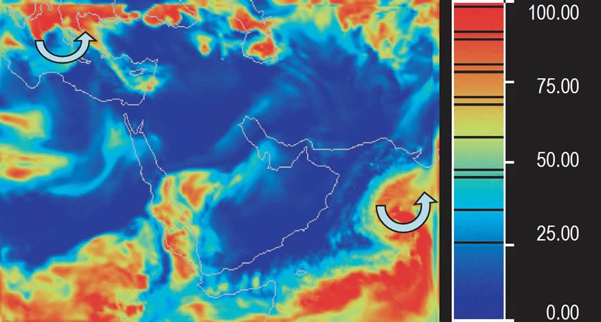
Fig. 29. Relative humidity at 15 km (~49,200 ft) altitude at 00Z on Sunday, June 3. Scale is in percent relative humidity. Red area is high relative humidity and blue is low relative humidity. Arrows indicate regions of cyclonic flow.
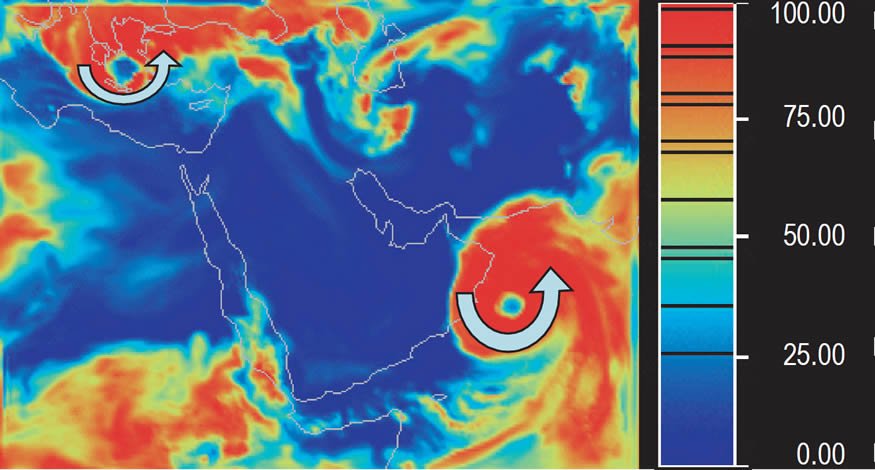
Fig. 30. Relative humidity at 15 km (~49,200 ft) altitude at 00Z on Monday, June 4. Scale is in percent relative humidity. Red area is high relative humidity and blue is low relative humidity. Arrows indicate regions of cyclonic flow.
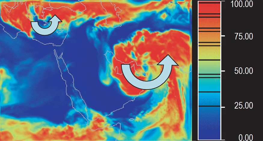
Fig. 31. Relative humidity at 15 km (~49,200 ft) altitude at 00Z on Tuesday, June 5. Scale is in percent relative humidity. Red area is high relative humidity and blue is low relative humidity. Arrows indicate regions of cyclonic flow.
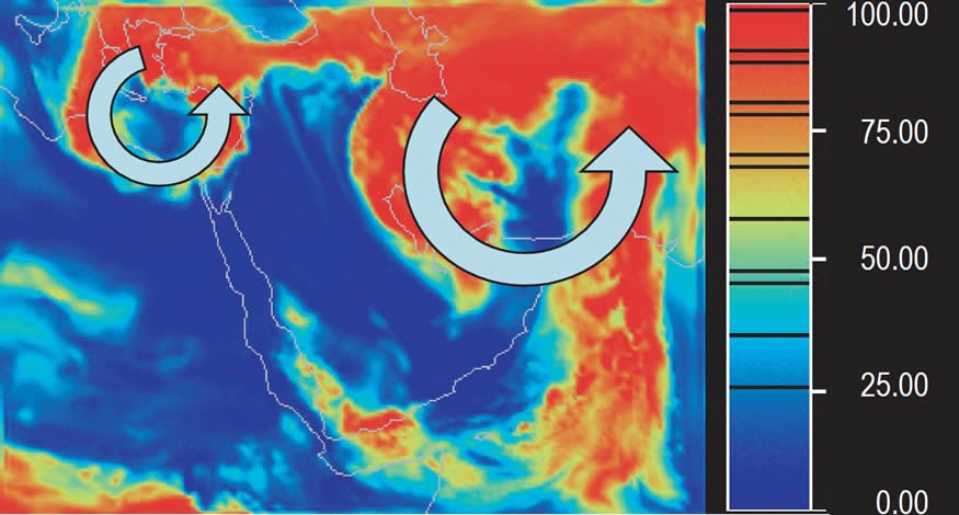
Fig. 32. Relative humidity at 15 km (~49,200 ft) altitude at 00Z, Wednesday, June 6. Scale is in percent relative humidity. Red area is high relative humidity and blue is low relative humidity. Arrows indicate regions of cyclonic flow.
Relative humidity in the western and central portion of the domain over Egypt and Saudi Arabia was more sporadic. Large areas of low relative humidity predominated over Egypt and Saudi Arabia much of the time. But, areas of high humidity frequently broke off from the north and northwestern portions of the domain over the eastern Mediterranean Sea and drifted southward over Egypt and Saudi Arabia in conjunction with the low-level closed circulations traveling on the larger-scale low-level jet like those seen in Figs. 17–20.
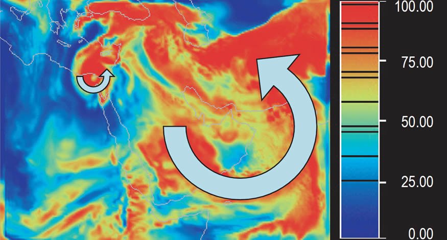
Fig. 33. Relative humidity at 15 km (~49,200 ft) altitude at 00Z, Sunday, June 17. Scale is in percent relative humidity. Red area is high relative humidity and blue is low relative humidity. Arrows indicate regions of cyclonic flow.
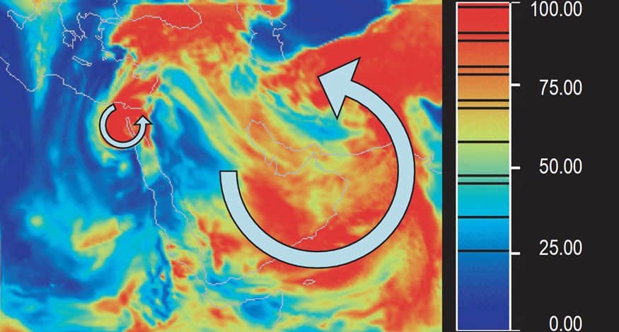
Fig. 34. Relative humidity at 15 km (~49,200 ft) altitude at 00Z, Monday, June 18. Scale is in percent relative humidity. Red area is high relative humidity and blue is low relative humidity. Arrows indicate regions of cyclonic flow.
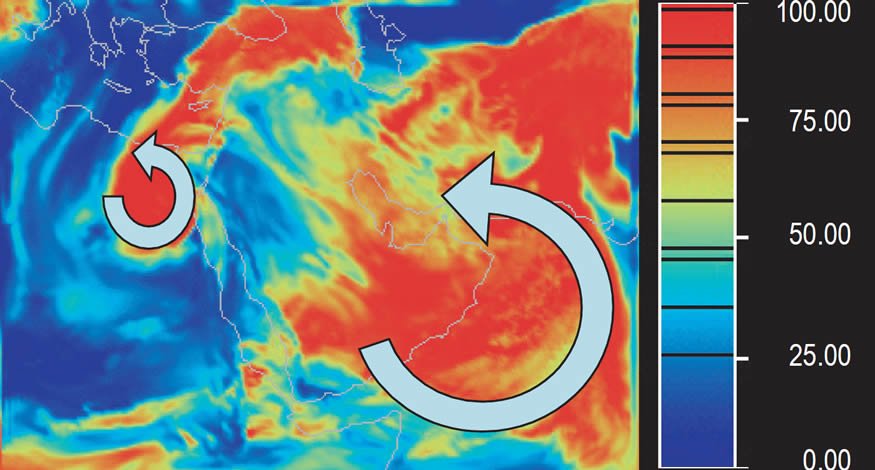
Fig. 35. Relative humidity at 15 km (~49,200 ft) altitude at 00Z, Tuesday, June 19. Scale is in percent relative humidity. Red area is high relative humidity and blue is low relative humidity. Arrows indicate regions of cyclonic flow.
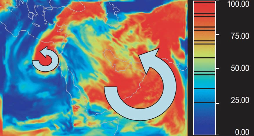
Fig. 36. Relative humidity at 15 km (~49,200 ft) altitude at 00Z, Wednesday, June 20. Scale is in percent relative humidity. Red area is high relative humidity and blue is low relative humidity. Arrows indicate regions of cyclonic flow.
Near the end of the simulation for hypercyclone Gonu a large region of high humidity became permanently located over the eastern end of the Persian Gulf and the northeastern region of the Arabian Sea. This large area of high humidity occurred in a low wind-speed region and was probably caused by high evaporation over the hot sea-surface temperatures of the Arabian Sea. This humidity drifted over Iraq, eastern Saudia Arabia, Afghanistan, and Pakistan all the way northward to the Himalayas. Because stronger winds to the east flowed northward from the warm Arabian Sea uphill to the Himalayas, large quantities of precipitation likely flooded the Indus River Valley. In addition, the condensation of large quantities of humidity to rain over the Himalayas would have formed a permanent, highly-efficient chimney to lift moisture into the upper atmosphere. This moisture would have been transported by upper-level winds horizontally to fall as rain for long distances.
Hypercane GONU Relative Humidity at 15 km (~49,200 ft)
Precipitation
Fig. 37 shows the accumulated precipitation over the domain for hypercyclone Gonu for 48 hours from 00Z on Saturday, June 2, 2007 to 00Z on Monday, June 4, 2007. This was the period when hypercyclone Gonu was intensifying after sea-surface temperature was increased by about 10C° (18F°) above the actual observed temperature. The maximum 48-hour accumulated precipitation was about 1,200 mm (48 in) in the rain bands around hypercyclone Gonu. This is the equivalent of about 25 mm/hr (1 in/hr). The instantaneous rate directly under a rain band would have been much greater if the cyclone had been standing still. However, the rate at a given location was reduced because the cyclone was moving northwestward at a speed of about 27 km/hour (~17 mph). Precipitation at a similar rate occurred over much of the Arabian Sea. This latter precipitation was due to widespread, unorganized convection at the warm sea-surface temperature.
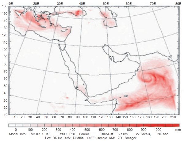
Fig. 37. 48-hour accumulated precipitation from 00Z, Saturday, June 2 to 00Z, Monday, June 4, 2007.
Fig. 38 shows the accumulated precipitation over the domain for hypercyclone Gonu for 18 days from 00Z on Saturday, June 2, 2007 to 00Z on Wednesday, June 20, 2007. This was the entire period of simulation for hypercyclone Gonu. The maximum 432-hour (18 days) accumulated precipitation was over 8,000 mm (320 in) in a north/south swath from the central Arabian Sea to Pakistan centered over Karachi. This swath of heavy rain occurred in conjunction with the continuous low-level jet from south to north over the Central Arabian Sea caused by the large-scale circulation over the entire Middle East. The average rainfall rate over the 432 hours is equivalent to about 18.5 mm/hr (~.75 in/hr). This rate of rainfall over the 18-day period would have produced massive flooding in the lower Indus River.
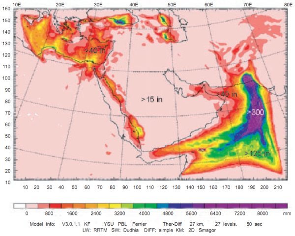
Fig. 38. 432 hours of accumulated precipitation from 00Z, Saturday, June 2 to 00Z, Wednesday, June 20, 2007.
A region of greater than 1,000 mm (~40 in) accumulated precipitation for the 432 hours covered almost the entire Arabian Sea, the Gulf of Oman, and most of Pakistan. In addition, an accumulation of more than 1,000 mm (~40 in) covered most of the Mediterranean, northern Egypt, and the eastern shore of the Red Sea during the entire period. The average rate over the 18-day period for these regions would have exceeded about 2.3 mm/hr (0.1 in/hour), but was probably highly variable. It is apparent from the pattern of the precipitation in the Arabian Sea that the westerly and southerly winds drew the moisture from the entire sea. The heat and moisture converted to precipitation provided the energy source for the entire circulation.
Discussion
Boundary conditions
The effects of the simulation boundaries appear to be limited to less than about 100 km (~62 miles). Examples of the small amount of distortion by the boundaries can be seen on the right sides of Figs. 13, 22, and 30. Meteorological results in the middle of the domain seems to behave properly according to normal expectations.
A few reviewers expressed concerns that cyclones forming over the eastern Mediterranean Sea may be due to boundary effects. However, we believe these cyclones are to be expected from the hot sea-surface temperatures prescribed there. We believe the hot sea-surface temperatures in the Mediterranean Sea are appropriate given evidence for catastrophic sub-marine activity there. However, additional simulations with a larger domain are recommended with and without hot sea-surface temperatures in the Mediterranean Sea. The large-scale circulation found in this study was not expected or a larger domain would have been used. We used three nested domains, but the one reported here is the largest of the three.
Other simulations
A simulation of a second storm—TS01a in June of 2002—produced similar wind, humidity, and precipitation patterns over the Middle East. It was not as intense or as large as Gonu and had a path farther to the southwest striking Yemen rather than Oman. But, when sea-surface temperatures of 40°C (104°F) were applied it grew to similar hypercyclone size and intensity. The only significant differences were a slightly different path of the hypercyclone when it made landfall and a different center for the large circulation. TS01a made a sudden right-hand turn at the coast of Yemen and followed the coastline east to Oman and then entered Iran like hypercyclone Gonu. The large-scale circulation over Saudi Arabia was displaced farther to the east than Gonu and small-scale circulations which formed in the eastern Mediterranean traveled southward over Saudi Arabia rather than over Egypt.
Conclusions
A hot Arabian Sea produced hypercyclone Gonu
Raising the sea-surface temperature in the Arabian Sea causes cyclones, which occasionally form there, to grow into giant cyclones, coined here as hypercyclones. Cyclone Gonu grew into a category 5+ hypercyclone with winds 50% greater and precipitation over twice as much as the actual cyclone. Because sea-surface temperature was increased to only 40°C (104°F), about 10C° (18F°) above the normal sea-surface temperature in the Arabian Sea, hypercyclone Gonu did not grow as much as Vardiman (2003) and Zavacky (2002) found when they raised the sea-surface temperature by over 20C° (36F°) above normal for their hypercane Florence case in the Gulf of Mexico. It is likely that if the sea-surface temperature in the Arabian Sea had been warmed by the same amount it would have displayed similar increases in wind speed and precipitation. Simulation of a second cyclone—TS01a—of May, 2002 produced similar results as hypercyclone Gonu.
Hot sea-surface temperatures created a large counter-clockwise, low-level circulation over the Middle East
Increased sizes and intensities of hypercyclones had been anticipated when sea-surface temperature was increased in the Arabian Sea, but a major change in the large-scale, low-level circulation over the Middle East had not been expected. The simulation showed that a large counter-clockwise circulation near the surface and a clockwise circulation aloft developed over the entire Middle East for hot sea-surface temperatures. The circulation had a diameter of about 5,000 km (~3,000 miles), and the circulation at the surface exceeded 65 m/s (~145 mph) after hypercyclone Gonu exited the area. During the development of hypercyclone Gonu the winds in the clockwise circulation high in the atmosphere exceeded 130 m/s (~290 mph). The western leg of the closed circulation brought moisture southward from the Mediterranean into Africa and Saudi Arabia and the southern leg brought moisture off the Arabian Sea into the Persian Gulf region.
High relative humidity occurred over the Gulf of Oman and the eastern Mediterranean
The high wind speed in the southern and eastern legs of the counter-clockwise circulation over the hot Arabian Sea transported large amounts of moisture to the Gulf of Oman and vicinity. The Gulf of Oman and the coasts of Iran and Pakistan were the targets for most of the flow. As the warm, moist air encountered the mountains of Oman, Iran, Pakistan, and Afghanistan, it was lofted upward by orographic and convective effects and moistened the middle and upper atmosphere. The moisture was then dispersed northward and westward across the northern part of the Middle East and Turkey. Moisture was also released from the Mediterranean Sea and drifted into Israel, Syria, and Jordan.
Intermittent high relative humidity occurred over the deserts of the Middle East
The southward flow of air in the western leg of the counter-clockwise circulation brought intermittent large amounts of moisture from the Mediterranean into Egypt, the Sudan, Ethiopia, and Saudi Arabia. A preferred path seemed to occur along the low terrain of the Red Sea, but humidity was also transported to all the deserts of North Africa and Saudi Arabia.
Heavy rain occurred over the Arabian Sea and Pakistan
Heavy rain was produced on Oman as hypercyclone Gonu moved northwestward across the Arabian Sea into the Gulf of Oman exceeding 1,200 mm (~48 in) compared to about 600 mm (~24 in) for the actual cyclone. In addition, the eastern leg of the counter-clockwise circulation produced continuous heavy rain over the center of the Arabian Sea and near Karachi, Pakistan at a rate of about 25 mm/hr (~1 in/hr) after the hypercyclone entered Iran. During the 18 days of numerical simulation over 8,000 mm (320 in) of rain fell over the central Arabian Sea and Pakistan. Heavy rain also fell farther inland at higher terrain in Pakistan and Afghanistan. Some of this precipitation could have fallen as snow in the mountains which later melted and contributed to floods along the Indus River. Regions of heavy precipitation like this could have fallen in mountainous areas of the Middle East at various times causing flooding.
Moderate rain occurred in Egypt, Israel, the Red Sea, Oman, Iran, and Afghanistan
Moderate rain exceeding about 1,000 mm (~40 in) occurred near the sources of humidity, such as the eastern Mediterranean, the Red Sea and the Gulf of Oman. If the water source was large like the Arabian Sea, the precipitation was heavy. However, if the source was smaller, the precipitation was less. In addition, the precipitation fell downwind of the source. For example, moderate rain fell in Egypt, Israel, and along the western coast of Saudi Arabia, which are all downwind of the Mediterranean Sea and the Red Sea in the western leg of the southeastward, low-level counter-clockwise circulation. Moderate rain also fell on the periphery of the intense precipitation region of the Arabian Sea. A branch of the eastern leg of the counter-clockwise circulation flowed westward into the Gulf of Oman and even into the Persian Gulf. Finally, a moderate amount of precipitation fell in Pakistan and Afghanistan downwind of the most intense region of rain over the hot Arabian Sea. Although these regions to the north are far from the source of moisture, the terrain continually rises all the way to the Himalayas, condensing moisture as the air is lifted up the slope.
Light rain fell throughout the Middle East causing well-watered deserts
Throughout the Middle East light rain greater than 380 mm (~15 in) fell, producing much wetter conditions than are now present. There are places in the deserts of North Africa and Saudi Arabia today that rain has not fallen for tens of years. The only vegetation in these deserts is found at oases located at the foot of wadis or near subterranean sources of water. When occasional rain falls, vegetation springs up quickly, but only lasts for a short time. Under the conditions simulated in this study it is likely that permanent vegetation would cover much of the sand and rocky soil in these regions.
Recommendations
It is possible that the generation of all the modern ocean floor via seafloor spreading processes during the Flood could have resulted in sea-surface temperatures even warmer than 40°C (104°F). It would be informative to try the same simulation at hotter sea-surface temperatures, particularly 45°C (113°F) and 50°C (122°F). The large-scale circulation and precipitation established over the Middle East by the warm Arabian Sea was large enough to overfill the domain used in the simulation which causes concerns about boundary effects. It would be useful to evaluate the same conditions applied in this study for a larger domain to insure that the boundaries did not adversely influence the results. The primary purpose of this study was to determine if rainfall could have been greater for several hundred years after the Genesis Flood, producing greater vegetation throughout the Middle East. Now that a successful model has been developed indicating more rainfall, it would be beneficial to quantify the effects of the increased rainfall on vegetation. And, finally, heavy precipitation would have likely caused flooding and erosion in specific locations. It might be interesting to evaluate the amount of flooding where heavy precipitation was most likely to have occurred, particularly along the Indus River near Karachi, Pakistan.
Acknowledgments
The mesoscale model (WRF) and topographical data used in this study are developed and maintained by the National Center for Atmospheric Research (NCAR) available at http://www.wrf-model.org. The meteorological data used in this study were downloaded from the Research Data Archive (RDA) which is maintained by the computational and Information Systems Laboratory (CISL) at the National Center for Atmospheric Research (NCAR). NCAR is sponsored by the National Science Foundation (NSF). The original data were available from the RDA (http://dss.ucar.edu) in dataset number ds083.2. Discussions with John Morris and Jim Johnson of the Institute for Creation Research prompted this project during discussions about a possible explanation for dividing of the earth in the days of Peleg (Morris and Johnson 2009). We appreciate the reviewers for editing the manuscript and offering improvements. This research was funded by the National Creation Research Foundation at the Institute for Creation Research.
References
Al-Katheri, A. A., A. Radi, and A. Dhanhani. 2008. Assimilation and simulation of Cyclone Gonu (2007) using the UAE WRFVAR system. WRF User’s Workshop, National Center for Atmospheric Research June 23–27, Boulder, Colorado. Retrieved from http://www.mmm.ucar.edu/wrf/users/workshops/WS2008/abstracts/P5-08.pdf.
Austin, S. A., J. R. Baumgardner, A. A. Snelling, L. Vardiman, and K. P. Wise. 1994. Catastrophic plate tectonics: A global Flood model of earth history. In Proceedings of the Third International Conference on Creationism, ed. R. E. Walsh, pp. 609–621. Pittsburgh, Pennsylvania: Creation Science Fellowship. Retrieved from http://www.icr.org/article/catastrophic-plate-tectonics-flood-model/.
Biblos online Bible maps. 2010. Retrieved from http://Bibleatlas.org.
Bradley, R. S. 1985. Paleoclimatology: Reconstructing climates of the Quaternary, 2nd ed. International Geophysics Series, vol. 68, eds. R. Dmowska and J. R. Holton, pp. 285–336. London: Elsevier, Academic Press.
Crowley, T. J. and G. R. North. 1991. Paleoclimatology. Oxford Monographs on Geology and Geophysics no. 18, pp. 71–91. New York: Oxford University Press.
Emanuel, K. A. 1987. The dependence of hurricane intensity on climate. Nature 326:483–485.
Emanuel, K. A. 1991. The theory of hurricanes. Annual Reviews of Fluid Mechanics 23:179–196. Retrieved from http://www.math.nyu.edu/caos_teaching/hurricanes/emanuel91.pdf.
Gonu 2007. Retrieved from http://weather.unisys.com/hurricane/n_indian/2007/index.html.
Gray, W. M. 1968. Global view of the origin of tropical disturbances and storms. Monthly Weather Review 96:669–700.
Heezen, B. and M. Tharp. 1977. Map of the world ocean floor. Office of Naval Research, Columbia University. Retrieved from http://www.columbia.edu/cu/news/06/08/tharp.html.
Meiggs, R. 1982. Trees and timber in the ancient Mediterranean world, 553 pp. London: Oxford University Press.
Morris, J. and J. Johnson. 2009. Rightly “dividing” the word about Peleg: Was Earth’s unusual “division” in Peleg’s lifetime a linguistic event or a geological event? Presented at the Creation Research Society, in Lancaster, South Carolina, on July 10, 2009. Retrieved from http://www.icr.org/i/pdf/technical/Rightly-Dividing-the-Word-about-Peleg.pdf.
NASA. 1994. Space radar image of Safsaf, North Africa. Retrieved from http://visibleearth.nasa.gov/view_rec.php?id=629.
NASA. 2007a. Global sea-surface temperature (SST) derived from satellite data. Retrieved from http://weather.unisys.com/archive/sst/sst-070610.gif.
NASA. 2007b. Visible satellite image of Tropical Cyclone Gonu. Retrieved from http://earthobservatory.nasa.gov/images/imagerecords/18000/18440/gonu/tmo_2007156_lrg.jpg.
NCAR. 2003. MM5 model. Retrieved from http://www.mmm.ucar.edu/mm5/.
NCAR, 2007. WRF model retrieved from http://www.wrf-model.org/index.php.
Oard, M. J. 1990. An ice age caused by the Genesis Flood, 243 pp. El Cajon, California: Institute for Creation Research.
Thirgood, J. V. 1981. Man and the Mediterranean forest: A history of resource depletion. London: Academic Press.
TS01a. 2002. Retrieved from http://weather.unisys.com/hurrican/n_indian/2002H/index.html.
Vardiman, L. 2003. Hypercanes following the Genesis Flood. In Proceedings of the Fifth International Conference on Creationism, ed. R. L. Ivey, Jr., pp. 17–28. Pittsburgh, Pennsylvania: Creation Science Fellowship.
Vardiman, L. and W. Brewer. 2010a. Numerical Simulation of Precipitation in Yosemite National Park with a Warm Ocean: A Pineapple Express Case Study. Answers Research Journal 3:23–36.
Vardiman, L. and W. Brewer. 2010b. Numerical Simulation of Precipitation in Yosemite National Park with a Warm Ocean: Deep Upper Low and Rex Blocking Pattern Case Studies. Answers Research Journal 3:119–145.
Vardiman, L. and W. Brewer. 2010c. Numerical Simulation of Precipitation in Yellowstone National Park with a Warm Ocean: Continuous Zonal Flow, Gulf of Alaska Low, and Plunging Western Low Case Studies. Answers Research Journal 3:209–266.
Wikipedia. 2007a. Track of Tropical Cyclone Gonu. Retrieved from http://upload.wikimedia.org/wikipedia/commons/0/04/Gonu_2007_track.png.
Wikipedia. 2007b. Accumulated precipitation from Tropical Cyclone Gonu near Oman from May 31–June 7, 2007. Retrieved from http://en.wikipedia.org/wiki/File:Gonu_rainfall.jpg.
Wood, B. G. 2008. The discovery of the sin cities of Sodom and Gomorrah. Bible and Spade, April 16, 2008. Retrieved from http://www.biblearchaeology.org/post/2008/04/16/The-Discovery-of-the-Sin-Cities-of-Sodom-and-Gomorrah.aspx.
Zavacky, N. 2002. Hurricane response to extreme sea surface temperatures. Masters Thesis, Institute for Creation Research, San Diego, California.
