The views expressed in this paper are those of the writer(s) and are not necessarily those of the ARJ Editor or Answers in Genesis.
Abstract
This paper is primarily a defense of my claim that Iraq is divided by an ancient curved escarpment stretching between Hit and Samarra. This geological formation is shown to be a relict shoreline where the post-Flood waters rested after the earth dried up. The Griffith and White challenge to this does not hold up; they mistakenly claim that the close-by and far more recent Tharthar depression in Iraq is what I am referring to. There are implications for the location of the Tower of Babel in this disagreement; those who erroneously believe that the Tower was built in south Iraq do not understand that the entire area below the escarpment was under water when the Tower was built. The southern half of Iraq is a delta that was formed by sediments from the Ice Age meltdown, and all structures built on it are post Ice Age. Therefore Babel and Babylon are not to be confused; the former was built in Northern Mesopotamia and the latter was located in southern Iraq, south of the Hit–Samarra escarpment.
Keywords: Iraq escarpment; Tharthar depression; Persian Gulf shoreline; Tower of Babel
Introduction
The recent paper by Griffith and White (2024) claiming that I have made a major geological error in my paper on the location of the Tower of Babel (Habermehl 2011) is itself greatly in error. Griffith and White have confused the geologically recent Tharthar Depression in Iraq with the ancient post-Flood escarpment that lies between Hit (also called Heet) and Samarra. The escarpment and the Tharthar Depression are two different geological formations that happen to be located near each other, as will be shown below.
What is the Hit–Samarra Escarpment?
The escarpment is an ancient curved ridge that stretches from near Hit on the Euphrates to just below Samarra on the Tigris in Iraq (see fig. 1). It divides Iraq in half. The territory south of this escarpment is the alluvium of Iraq, a deposit that was washed down from the Turkish mountains to the north and the Zagros mountains to the east in the Ice Age meltdown to form a delta. There is a distinct difference between the northern and southern parts of Iraq (Habermehl 2011).
There are geologists who believe that this escarpment is an ancient shoreline that would have marked the head of the Persian Gulf at a distant time in the past. This escarpment was noted by De Morgan in 1900 as a reconstructed head of the Gulf between Hit and Samarra 8,000–5,000 years ago (Sissikian et al. 2020). Also Lloyd in 1943 showed that the Head of the Persian Gulf was about 108 km NW of Baghdad before 4000 BC. This is basically the same location as the Hit-Samarra line) (Sissikian et al. 2020).
In addition I quote from my Babel paper (Habermehl 2011):
There is an important geological feature in Iraq that runs roughly east–west from the Euphrates to the Tigris, north of Baghdad, from Ramadi (near Hit) to Samarra. This curving ridge or escarpment, about 6–15 m (19–49 ft) high, is located at an altitude of about 76 m (249 ft) and is considered to be an ancient ocean shoreline (Boesch 1939; Guest 1953; Held 2000, p. 337; Lloyd 1955, pp. 16–17, 29; Maisels 1993, p. 87). The altitude of this ridge is significant because it sits right in the range of 70–80 m (229–262 ft) where the ocean shoreline might be today if all the global ice on land melted, as already noted.
Fig. 1 shows how this feature, described by Ragozin (1893, p. 1) as “a pale, undulating line,” and by Held (2000, p. 337) as “a sinuous cliff, probably the feature for which Iraq is named,” divides Iraq into two parts: the northern section (called al Jezirah, meaning “the island”) that is desert and rocky, and the southern delta, the alluvium, that is quite different in character (Aqrawi, Domas, and Jassim 2006, p. 22; Johns 1913, p. 13; Potts 1997, p. 2 map). About this cliff, the nineteenth-century traveler, Rawlinson (1885, p. 3) wrote:
“But nature has set a permanent mark, half way down the Mesopotamian lowland, by a difference of geological structure, which is very conspicuous. Near Hit on the Euphrates, and a little below Samarra on the Tigris, the traveller who descends the streams, bids adieu to a somewhat waving and slightly elevated plain of secondary formation, and enters on the dead flat and low level of the mere alluvium. The line thus formed is marked and invariable; it constitutes the only natural division between the upper and lower portions of the valley; and both probability and history point to it as the actual boundary between Chaldaea and her northern neighbor.”
Fig. 1, mentioned in the quote above, is in the Babel paper, and is reproduced as fig. 1 in this paper. Together the references in the above quote constitute strong evidence for the existence of this escarpment. These referenced authors do not consider this ancient escarpment ridge as nonexistent, as Griffith and White claim in their seriously flawed misunderstanding of geology. In addition, the references in that paper for what the altitude of the ocean would be if all the ice on earth melted are Alley et al. (2005) and Poore, Williams, and Tracey (2000).
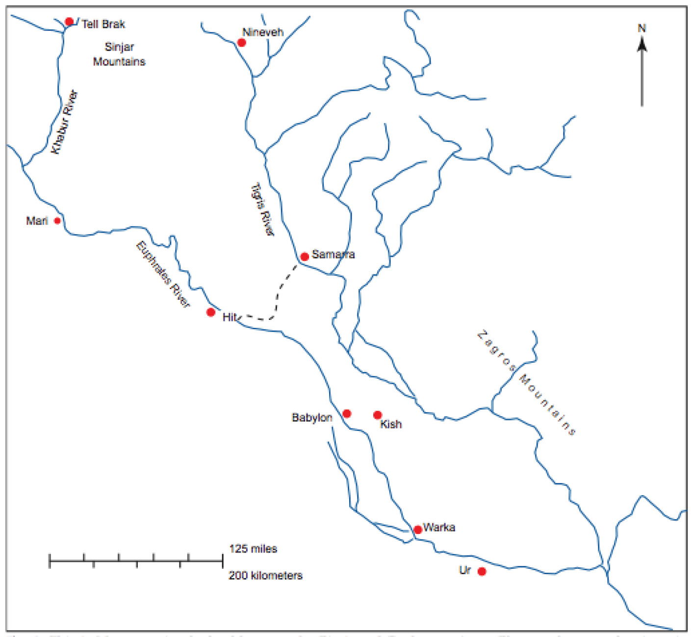
Fig. 1. The map above shows Mesopotamia, the land between the Tigris and Euphrates rivers, today called Iraq. The dotted line is the escarpment that marks an ancient shoreline, dividing the north from the south. The Tharthar Depression, incorrectly claimed by Griffith and White to be this escarpment, is a territory just north of the dotted line curve. (This map appears as fig. 1 in Habermehl 2011.)
What this shoreline was becomes clear if we look at it from a biblical point of view. If all the ice now on earth melted, the ocean level would rise to where the waters settled immediately after the Flood. That just happens to be the elevation where the escarpment lies (as noted above). I show this clearly in the Babel paper. Did Griffith and White miss this, or did they not understand it? Either way, they are wrong in claiming that I am in error on the escarpment.
This ancient shoreline dates from the post-Flood settling of the water, about 2,350 years (MT) or 3,300 years (LXX) BC. However, on the extremely stretched-out secular timeline, Noah’s Flood was at least 235 million years ago, because the dinosaurs first appeared then after the Flood (Norman 2017, 6, 9). This would put the formation of the escarpment at least that far back in time on the standard secular timeline.
What Is the Tharthar Depression?
This depression, mistaken by Griffith and White for the escarpment ridge shoreline, was formed some time in the Holocene (a period between 11,700 secular years ago and the present) (Sissilian 2011; Walker et al. 2009). In other words, it formed post Ice Age. This is a lot later than the end of the Flood when, as I show above, the escarpment would have formed. (How much later depends on whether we are calculating according to the MT or LXX). As I have shown in past writings, the Ice Age ended some time before Abraham (for example, Habermehl 2013). This makes the Tharthar depression relatively recent in earth’s history compared to the escarpment. (The depression is in the same place as the current artificial Lake Tharthar that was formed in 1956) (Sissakian 2011). It appears that this lake formed in the depression that is located just north of the escarpment.
The Tharthar Depression is shaped like an enclosed drop-shaped bowl; by comparison, the escarpment is a ridge that stretches from Hit to Samarra. The two are two quite different formations and it is difficult to see how they can be confused. The depression was formed by the process of karstification (Schultz n.d.; Sissakian 2011). Fig. 1 in my Babylon paper shows that the escarpment line is sharply curved below the depression.
The roughly east–west width of the depression is 48 km (Sissakian 2011). However, the direct distance as the crow flies from Hit to Samarra is 115 km (Travelmath 2024), more than twice that distance. If you drive the curved road between the two cities, the distance is 180 km, which shows how sharply curved the road around the bottom of the depression is. Either way, the width of the Tharthar Depression is a great deal less than the length of the escarpment between Hit and Samarra.
In fig. 1 of the Griffith and White reply to Osgood (2024), their red line drawing of the bottom edge of the Tharthar Depression is very inaccurate. Their line incorrectly shows the Depression reaching almost from the Euphrates to the Tigris Rivers. However, the actual size of the Depression, as I show above, is less than half that distance.
In addition, there is a difference between the two formations in that the southern rim of the depression faces north while the escarpment ridge faces south.
The Point of This Reply
Griffith and White have misunderstood the geology and have mistaken two very different formations for each other. Their characterization of my work as a “bad argument” is not acceptable. The ancient Hit–Samarra escarpment and more recent Tharthar Depression of Iraq are two totally different geological formations that must not be confused.
I therefore stand behind not only the escarpment in Iraq as an ancient shoreline, but I also stand behind the entire thesis of my paper on the location of the City and Tower of Babel.
References
Alley, Richard B., Peter U. Clark, Philippe H. Huybrechts, and Ian Joughin. 2005. “Ice-Sheet and Sea-Level Changes.” Science 310, no. 5747 (October 21): 456–460.
Aqrawi, Adnan A. M., Jaroslav Domas, and Saad Z. Jassim. 2006. “Quaternary Deposits.” In Geology of Iraq. Edited by Saad Z. Jassim, and Jeremy C. Goff, 185–197. Brno, Czech Republic: Dolin, Prague and Moravian Museum.
Boesch, Hans H. 1939. “El-’Iraq.” Economic Geography 15, no. 4 (October): 325–361.
Griffith, Kenneth C., and Darrell K. White. 2024. “Where in the World is the Tower of Babel? Reply to Osgood.” Answers Research Journal 17 (July 17): 435–438. https://answersresearchjournal.org/tower-of-babel/where-is-tower-babel-reply/.
Guest, E. R. 1953. “The Rustam Herbarium, ‘Iraq: Part VI. General and Ecological Account.” Kew Bulletin 8, no. 3: 383–403.
Habermehl, Anne. 2011. “Where in the World Is the Tower of Babel?” Answers Research Journal 4 (March 23): 25–53. https://answersresearchjournal.org/where-is-the-tower-of-babel/.
Habermehl, Anne. 2013. “Ancient Egypt, the Ice Age, and Biblical Chronology.” In Proceedings of the Seventh International Conference on Creationism. Edited by Mark Horstemeyer, vol. 7, article 37. Pittsburgh, Pennsylvania: Creation Science Fellowship.
Held, C. C. 2000. Middle East Patterns: Places, Peoples, and Politics. 3rd ed. Boulder, Colorado: Westview Press.
Johns, Claude Hermann Walter. 1913. Ancient Babylonia. New York, New York: G. P. Putnam’s Sons.
Lloyd, Seton. 1955. Foundations in the Dust. Harmondsworth, England: Penguin Books.
Maisels, Charles Keith. 1993. The Near East: Archaeology in the ‘Cradle of Civilization’. London, United Kingdom: Routledge.
Norman, David. 2017. Dinosaurs: A Very Short Introduction. 2nd ed. Oxford, United Kingdom: Oxford University Press.
Poore, Richard Z, Richard S. Williams, Jr., and Christopher Tracey. 2000. “Sea Level and Climate.” U.S. Geological Survey Fact Sheet 002–00, 2 p. https://pubs.usgs.gov/fs/fs2-00/.
Potts, D. T. 1997. Mesopotamian Civilization: The Material Foundations. London, United Kingdom: The Athlone Press.
Ragozin, Zénaïde A. 1893. The Story of the Nations: The Story of Assyria From the Rise of the Empire to the Fall of Nineveh. New York, New York: G. P. Putnam’s Sons.
Rawlinson, George. 1885. The Seven Great Monarchies of the Ancient Eastern World: Vol. I. New York, New York: John B. Alden.
Schulte, K. n.d. “Karst Topography.” Libretexts Geosciences. https://geo.libretexts.org/Bookshelves/Geology/Fundamentals_of_Geology_(Schulte)/11%3A_Hydrology/11.14%3A_Karst_Topography.
Sissakian, Varoujan K. 2011. “Genesis and Age Estimation of the Tharthar Depression, Central West Iraq.” Iraqi Bulletin of Geology and Mining 7, no. 3: 47–62.
Sissakian, Varoujan K., Nasrat Admo, Nadhir Al-Ansari, Mukhalad Abdullah, and Jan Laue. 2020. “Sea Level Changes in the Mesopotamian Plain and Limits of the Arabian Gulf: A Critical Review.” Journal of Earth Sciences and Geotechnical Engineering 10, no. 4. 87–110
Travelmath. 2024. https://www.travelmath.com/distance/from/Samarra,+Iraq/to/Hit,+Iraq.
Walker, M., S. Johnsen, S. O. Rasmussen, T. Popp, J.-P. Steffensen, P. Gibrard, W. Hoek, et al. 2009. “Formal Definition and Dating of the GSSP (Global Stratotype Section and Point) for the Base of the Holocene Using the Greenland NGRIP Ice Core, and Selected Auxiliary Records.” Journal of Quaternary Science 24, no. 1 (January): 3–17.