The views expressed in this paper are those of the writer(s) and are not necessarily those of the ARJ Editor or Answers in Genesis.
Abstract
Two tropical cyclones were simulated with the NCAR WRF model to determine if warm sea-surface temperatures would cause them to intensify into hypercanes and follow similar storm tracks as the original cyclones. Hurricane Charley (2004) and Tropical Storm Fay (2008) were successfully replicated with the actual sea-surface temperature of about 30°C (86°F). The sea-surface temperature of the Atlantic Ocean was then warmed to 40°C (104°F) and winds, precipitation, and storm tracks compared to the actual storms. Both storms intensified, but not as much as had been anticipated, and the storm tracks diverged greatly from storm tracks of the actual cyclones. The reason appears to be the large cyclonic circulation which developed off the southeastern coast of the United States and steered the hypercanes away from Florida. Strong vertical wind shears also developed in the circulation which suppresses the intensification of hurricanes.
Keywords: NCAR, weather research and forecasting model, WRF, hurricane, hypercane, Hurricane Charley, Tropical Storm Fay, catastrophic plate tectonics
Catastrophic Plate Tectonics and Hypercanes
In the 1960s images of seafloor topography were first published showing a mid-ocean ridge which extends completely around the earth. Fig. 1 shows this mid-ocean ridge which is about 65,000 km (40,000 mi) long, up to 2 km (~6,600 ft) high relative to the ocean floor, and, in places, 1,000 km (~620 mi) wide. It is composed of basaltic rock that cooled from basaltic magma generated by partial melting of mantle rock beneath mid-ocean ridges. Some of this magma, whose temperature was about 1,200°C (2,200°F), flowed onto the seafloor surface to form, when it solidified, what is called pillow basalt. The catastrophic plate tectonics model (Austin et al. 1994) proposed that the mid-ocean ridges, almost in their entirety, formed from molten basaltic rock during the year of the Genesis Flood. The conventional view is that the molten rock was ejected over millions of years, warming the ocean only slightly. However, if the time span of their formation was only a year in duration, the heating rate would have been dramatically higher causing the oceans to warm considerably. The average ocean temperatures derived from analysis of foraminifera casts in sea-floor sediments show that the oceans were indeed much warmer (at least 35°C (95°F)) during the Cretaceous Period (Austin et al. 1994). Warmer oceans would in turn have resulted in elevated sea-surface temperatures following the Flood.
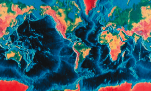
Fig. 1. Sea-floor topography derived from sonar depth measurements. The light blue linear features are the mid-ocean ridges (after Heezen and Tharp 1977).
Gray (1968) and Emanuel (1987) showed that a sea-surface temperature warmer than 26.5°C (80°F) is one of the conditions for the formation of hurricanes. Emanuel (1991) extended the theory of hurricane development for sea-surface temperatures warmer than those presently observed on earth and predicted the development of massive hurricanes he called hypercanes. Vardiman (2003) and Zavacky (2002) applied these ideas to an actual hurricane by simulating the development of Florence, a modest hurricane that occurred in the Gulf of Mexico in 1988, but with higher than observed sea-surface temperatures, in some cases as warm as 45°C (113°F). The result was a hypercane with horizontal and vertical winds twice as fast and precipitation rates ten times greater than the actual storm.
Circulation in Hurricanes
Hurricanes and cyclones are tropical systems that transform heat energy extracted from a warm ocean into kinetic energy of rotation. They function as very efficient heat engines driven by the temperature difference between a warm heat reservoir at the sea surface and a cold heat reservoir at the tropopause. In addition to numerous papers on the theory of hurricanes, Emanuel (2005) completed a book on the history and science of hurricanes while teaching at the Massachusetts Institute of Technology. He used an engineering approach to study the conversion of heat energy into the kinetic energy of motion in hurricanes. A portion of the heat energy comes from the transfer of heat from the sea surface, but a large amount also comes from the release of latent heat as water vapor drawn from the lower atmosphere condenses.
In the northern hemisphere, air spirals in a counter-clockwise direction toward the low-pressure center of a hurricane. The high-speed winds spiral inward to a point at which the inward pressure-gradient forces are balanced by the outward centrifugal forces of rotation. Fig. 2 shows how this air then rises upward in an eye-wall and flows outward aloft in a clockwise rotation. The highest horizontal and vertical winds, turbulence, and precipitation occur in this eye-wall. The airflow in the stratosphere aloft is cold and relatively dry, producing cirrus clouds. Satellite and radar images show that the airflow is counter-clockwise at low levels and clockwise aloft.
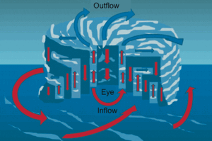
Fig. 2. Circulation in and around a hurricane or tropical cyclone. In the Northern Hemisphere warm moist air flows counter-clockwise into a hurricane at the surface, upward in the eye-wall, and clockwise outward as cold, dry air aloft.
Previous Simulations of Hurricanes over Hot Sea-Surface Temperatures
Austin et al. (1994) realized that if the Genesis Flood released large quantities of heat by catastrophic processes and produced hot sea-surface temperatures, as first proposed by Oard (1990), more intense and numerous hurricanes would have occurred after the Flood for many years. Zavacky (2002) and Vardiman (2003) simulated a weak hurricane—Hurricane Florence—which occurred in the Gulf of Mexico in 1988 with the NCAR (National Center for Atmospheric Research) mesoscale meteorology model (MM5) (NCAR 2003), the predecessor to the Weather Research and Forecasting model (WRF) (NCAR 2007). The actual hurricane maintained a steady-state intensity over a moderately warm sea-surface temperature for about 36 hours as it tracked slowly northward towards New Orleans. When sea-surface temperature was increased to 45°C (113°F) the simulated hurricane grew into a gigantic hypercane filling the entire Gulf of Mexico, doubling the horizontal and vertical winds, and increasing the precipitation by a factor of ten. Hypercane Florence followed the same track as the observed Hurricane Florence.
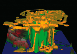
Fig. 3. A simulation of Hypercane Florence at 20 hours after increasing the sea-surface temperature in the Gulf of Mexico. Yellow is cloud boundary and green is precipitation (Vardiman 2003).
Fig. 3 shows simulated Hypercane Florence 20 hours after sea-surface temperature was increased from 30°C (86°F) to 45°C (113°F). The yellow region displays cloud and the green region precipitation. Note that the horizontal winds rotated counterclockwise so fast near the bottom of the storm that the cloud and precipitation towers leaned downwind with altitude. The cirrus anvil at the top of the storm grew dramatically in size and covered not only the Gulf of Mexico but most of the eastern United States. Hypercane Florence far exceeded a category 5 hurricane at the end of the simulation. Such an intense and massive storm is not observed today, but likely did under conditions that existed after the Genesis Flood.
Zavacky (2002) conducted a more complete analysis of the simulation of Hurricane Florence at various sea-surface temperatures and determined that horizontal wind speed, pressure drop in the eye, and accumulated precipitation all depend on a highly non-linear relationship with sea-surface temperature. She also determined that the maximum wind speed could become as fast as 180 m/s (~400 mph)—over twice the wind speed of a category 5 hurricane. Winds of this speed would be expected to produce four times the damage of category 5 hurricanes because of the quadratic relationship between wind speed and the force on objects. Such storms would destroy almost all trees and structures on land surfaces. In addition, hypercanes would produce ten times the precipitation of category 5 storms as well as huge storm surges and flooding. All of these effects would be incredibly destructive.
Numerical Simulations of Hurricane Charley and Tropical Storm Fay
We selected the same Weather Research and Forecasting model (WRF) to simulate Hurricane Charley and Tropical Storm Fay that Vardiman and Brewer (2010a, 2010b, 2010c, 2011) used to simulate winter storms in Yosemite and Yellowstone National Parks and Hypercane Gonu in the Middle East. WRF is a numerical mesoscale model which computes wind, humidity, precipitation, and many other variables over a three-dimensional grid at any location and resolution on earth.
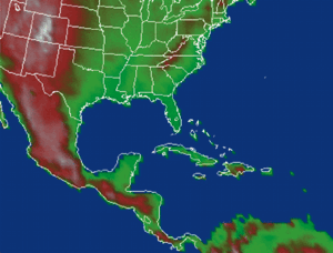
Fig. 4. Domain for simulation of Hurricane Charley and Tropical Storm Fay.
Fig. 4 shows the rectangular computational domain chosen for this study with the topography and political borders centered on Punta Gorda, Florida on the south-central coast of the United States at 27°N latitude, 82°W longitude. We actually made computations in three nested domains, each with the same number of grid points: 217 × 163. Each child domain was one-third the spacing of its parent, but because the moisture and wind fields around the tropical cyclones modeled by WRF migrated over relatively long distances, and we wished to observe the wind, humidity, and precipitation fields over the entire southeastern United States and the Caribbean, we chose the largest domain for our primary analysis. It extended from the coast of Guyana in South America in the southeast, to south central Idaho in the northwest, and from a point in the Pacific Ocean about 1,500 km (1,000 mi) southwest of the coast of Mexico, to a point in the Atlantic Ocean about 1,500 km (1,000 mi) due east of Long Island, New York, and southeast of Newfoundland in the northeast. The domain was 5,670 km (3,523 mi) east/west and 4,320 km (2,684 mi) north/south. Computations were performed using a computational grid with 210 cells east/west and 160 cells north/south, each 27 km (16.8 mi) on a side.
The highest terrain was over 4,250 m (14,000 ft) in Colorado decreasing southward through Mexico and Central America. Occasional peaks exceeded 1,500 m (5,280 ft) in the Appalachian Mountains, and the Dominican Republic had central mountains as high as 3,175 m (10,400 ft). Whenever a hurricane makes landfall or strong, moist winds flow over mountainous terrain, orographic clouds will product heavy precipitation even without convection.
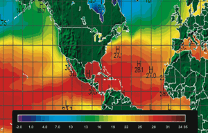
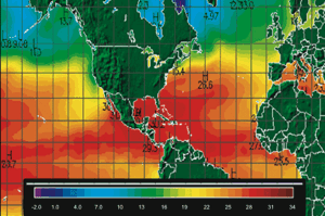
Fig. 5. Sea-surface temperature in °C during Hurricane Charley at 00Z (20:00 EDT) on August 17, 2004 (UNISYS 2004a).
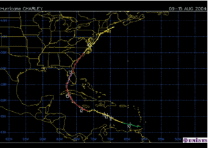
Fig. 6. Observed path of Hurricane Charley from August 9–15, 2004. Dates are shown on the path at 00Z (2000 EDT locally on previous day) (UNISYS 2004b). Colors indicate hurricane category—green (TD), yellow (TS), red (1), light red (2), magenta (3).
The meteorological data used in this study for Hurricane Charley (August 9–15, 2004) and Tropical Storm Fay (August 18–23, 2008) were obtained from the Research Data Archive (RDA) at the National Center for Atmospheric Research (NCAR) (http://dss.ucar.edu) in dataset number ds083.2 (http://dss.ucar.edu/datasets/ds083.2/). These National Centers for Environmental Prediction (NCEP) FNL (Final) operational global analysis data available in RDA are on 1.0 × 1.0 degree grids prepared operationally every six hours. This product is from the Global Data Assimilation System (GDAS), which continuously collects observational data from the Global Telecommunications System (GTS), and other sources, for many different analyses. The FNLs are made with the same model which NCEP uses in the Global Forecast System (GFS), but the FNLs are prepared about an hour or so after the GFS is initialized. The FNLs are delayed so that more observational data can be used. The GFS is run earlier in support of time critical forecast needs, and uses the FNL from the previous 6 hour cycle as part of its initialization. The analyses are available at the surface, at 26 mandatory (and other pressure) levels from 1000 mb to 10 mb, in the surface boundary layer and at some sigma layers, the tropopause and a few others. Parameters include surface pressure, sea level pressure, geopotential height, temperature, sea surface temperature, soil values, ice cover, relative humidity, u- and v- winds, vertical motion, vorticity, and ozone.
Hurricane Charley
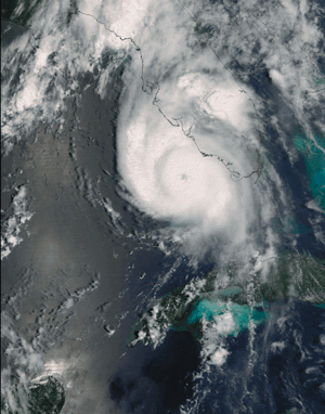
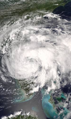
Fig. 7. Satellite image of Hurricane Charley at 16:35 UTC (12:35 EDT) on August 13, 2004 (NASA).
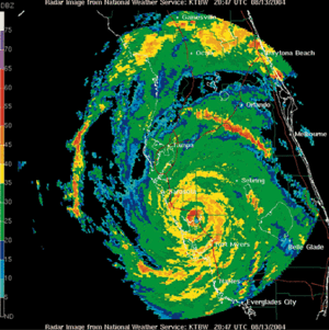
Fig. 8. Tampa Bay radar image of Hurricane Charley as it crossed Port Charlotte, Florida at 20:47 UTC (16:47 EDT) on August 13, 2004 (NOAA).
Fig. 5 shows the sea-surface temperatures observed on August 17, 2004 during the time Hurricane Charley was in northern Florida. Note that the sea-surface temperature south of Florida averaged about 30°C (86°F).
Fig. 6 shows the observed path of Hurricane Charley from August 9–15, 2004. Fig. 7 shows a satellite image of Hurricane Charley as it approached Port Charlotte, Florida on August 13, 2004 and Fig. 8 shows a radar image as Hurricane Charley crossed Port Charlotte.
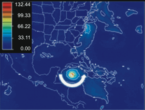
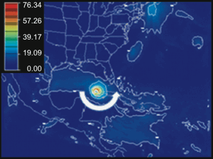
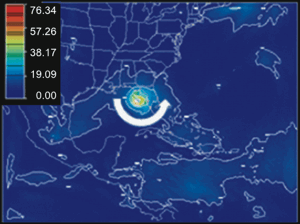
Figs. 9–12 show daily snapshots at 18Z (14:00 EDT) of the horizontal wind at the 500 mb level near 5 km (16,404 ft) above sea level for simulated Hurricane Charley during its passage from the Caribbean and across Florida. The path of simulated Hurricane Charley was very slightly to the west of the actual path, but crossed the coast of Florida at nearly the same time. The maximum observed wind speed was 63 m/s (142 mph) as actual Hurricane Charley crossed the coastline as a Category 4 storm. When simulated Hurricane Charley crossed the coast of Florida just north of Port Charlotte it had a wind speed of about 57 m/s (127.5 mph), almost the same as for observed Hurricane Charley. But, a maximum wind speed of 76 m/s (170 mph) occurred the day before on its path from Cuba to Florida.
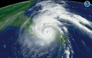
Fig. 15. Satellite image of Tropical Storm Fay on August 19, 2008 at 1815 Z (1415 EDT) (NOAA).
Tropical Storm Fay
Fig. 13 shows the sea-surface temperatures observed on August 16, 2008 during the time of Tropical Storm Fay. Note that the sea-surface temperature south of Florida averaged about 30°C (86°F).
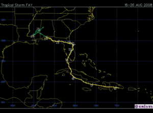
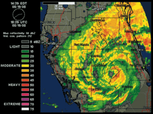
Fig. 14 shows the observed path of Tropical Storm Fay from August 15–26, 2008. Figs. 15 and 16 show satellite and radar images of Tropical Storm Fay as it approached Port Charlotte, Florida on August 19, 2008.
Figs. 17–20 show daily snapshots at 18Z (14:00 EDT) of the horizontal wind at 5 km (16,404 ft) above sea level for simulated Tropical Storm Fay during its passage from the Caribbean into Florida. The path of simulated Tropical Storm Fay was nearly identical to the actual path, and made landfall in Florida at nearly the same time and place. The maximum observed wind speed was 28 m/s (55 kts) in central Florida for about 6 hours after Tropical Storm Fay crossed the coastline. After simulated Tropical Storm Fay crossed the coast of Florida from Cuba it had a wind speed of about 30 m/s (~60 kts), but continued to increase in speed to about 35 m/s (~70 kts) when it crossed the east coast of Florida.
Hypercanes
For simulations of Hypercanes Charley and Fay we prescribed sea-surface temperatures of 40°C (104°F) for all water surfaces including the Pacific Ocean, the Sea of Cortez, the Atlantic Ocean, the Gulf of Mexico, and the Caribbean. Our reasoning was that sea-surface temperatures of at least 40° (104°F) are appropriate for these simulations because ocean circulation from the mid-ocean ridges in both the Atlantic and the Pacific Oceans likely would have transported heat to all sea surfaces surrounding Florida. Simulations with sea-surface temperatures at 50°C (122°F) became unstable and produced unrealistic results.
Hypercane Charley
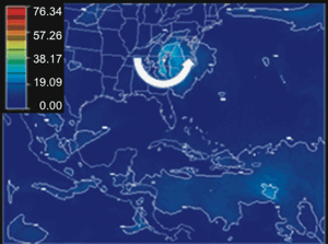
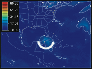
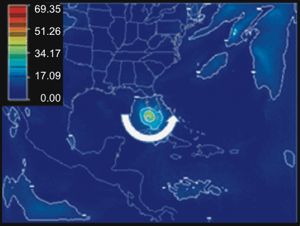
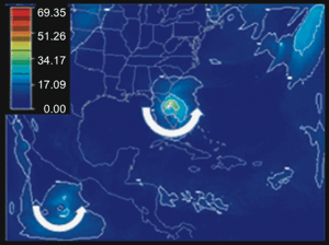
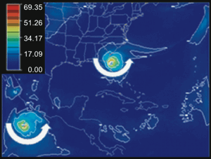
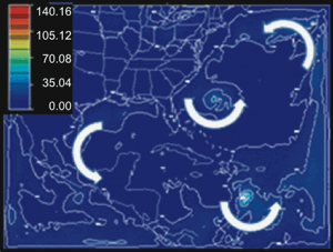
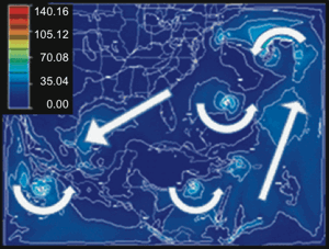
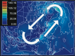
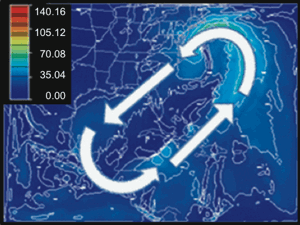
Figs. 21–26 show the horizontal winds at 5 km (16,404 ft) above sea level for simulated Hypercane Charley in daily increments for six days after the sea-surface temperature was raised to 40°C (104°F) on the first day. In comparison to Hurricane Charley which was a category 4 hurricane (winds between 56–67 m/s [113–135 kts]), simulated Hypercane Charley reached maximum winds of about 80 m/s (160 kts). However, the original circulation of Hypercane Charley lost its integrity and developed into a larger-scale circulation pattern which formed along the entire southern and southeastern coast of the United States. The temperature difference between the warm ocean surface and the cooler continental surface caused a counterclockwise circulation to appear in Fig. 21 and to strengthen during the six days of the simulation through Fig. 26.
Simulated Hypercane Charley developed from a tropical wave moving westward across the Atlantic and grew into a hurricane near Jamaica but changed its westerly direction of movement to a northeasterly direction when the sea-surface temperature was increased. It was steered in the southeasterly leg of the counterclockwise flow off the coast of the United States and was incorporated into a major center of circulation off the coast near New York City. Several other counterclockwise centers of circulation developed in the Caribbean and in the Gulf of Mexico and grew into hypercanes, and even in the Pacific Ocean off the coast of Mexico. These centers tended to remain near their source of heat and water vapor in the ocean.
Over the continental southeastern United States the return flow was from the northeast forming a doughnut-shaped flow centered on the eastern Gulf of Mexico and Florida. In this “hole” winds were light. The most intense region of the circulation occurred near New York where winds reached 80 m/s (160 kts) as the wind turned the corner.
Hypercane Fay
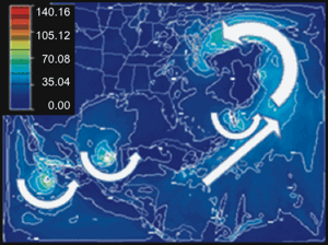
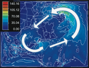
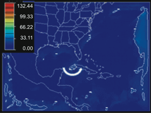
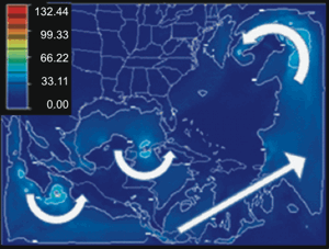
Figs. 27–31 show the horizontal winds at 5 km (16,404 ft) above sea level for simulated Hypercane Fay in daily increments for 5 days after the sea-surface temperature was raised to 40° (104°F).
In this case Tropical Storm Fay continued its northwestward movement into the Gulf of Mexico after the sea-surface temperature was increased, in contrast to the movement of Hypercane Charley. Hypercane Fay then took up residence in the Gulf and formed a major center of circulation for several days.
Simultaneously an even larger center of circulation formed off the east coast of the United States. Winds reached a maximum of 70 m/s (140 kts) in the small circulation in the Gulf of Mexico in Fig. 29 and 90 m/s (180 kts) in the large circulation off the east coast in Fig. 31.
Although the counterclockwise circulation off the southern and southeastern coasts of the United States developed more slowly and with a slightly different shape for Hypercane Fay than Hypercane Charley, it contained many of the same features—a large elongated, doughnut-shaped circulation with a northeasterly flow on the southeast side, a southwesterly flow on the northwest side, and a center with light winds in the “eye” centered over the eastern Gulf of Mexico and Florida.
It is likely that Hypercane Fay continued its northwest movement into the Gulf of Mexico during the development of the large-scale circulation because it was about 1,600 km (1,000 mi) farther west when the sea-surface temperature was warmed. Hypercane Fay was near the west end of Cuba when the sea-surface temperature was warmed and Hypercane Charley was south of the Dominican Republic. In both cases their paths were displaced and did not cross Florida. Previous simulations by Vardiman (2003) found that small-scale heating of the sea-surface temperature just beneath a hurricane caused it to simply increase in size and intensity but follow the same path as the original hurricane. In this study, the edge of the warmer sea-surface temperature near the eastern boundary of the domain may have strongly affected the wind fields and the movement of hypercanes. We have begun an effort to determine if the large circulation off the east coast is amplified by this effect.
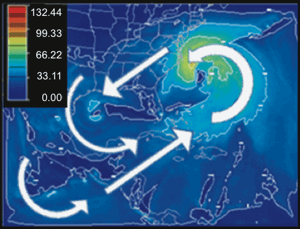
Fig. 31. Horizontal winds in m/s (~2 kts) at 5 km (16,404 ft) above sea level for Simulated Hypercane Fay at 18Z (1400 EDT) on Friday, August 22, 2008. Contours are in 20 m/s intervals. Arrows signify wind direction.
Comparison of Observed, Simulated, and Hypercane Results
Figs. 32 and 33 show comparisons of the observed, simulated, and hypercane tracks for Hurricane Charley and Tropical Storm Fay. The tracks in Fig. 32 for the observed (x) and simulated (o) cases of Hurricane Charley agreed fairly well. However, for the hypercane case (■) the track diverged strongly to the east. It was steered by the strong southerly winds which developed off the east coast of the United States when the sea-surface temperature was increased. The hypercane moved to a final position off the North Carolina/Virginia coast and remained trapped at the top of the broader circulation formed by the large temperature contrast between the land and the Atlantic Ocean.
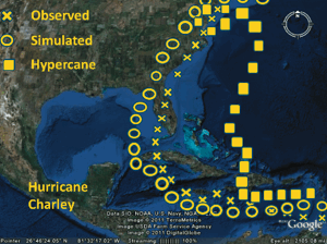
Fig. 32. Comparison of the tracks of observed, simulated, and hypercane cases for Hurricane Charley.
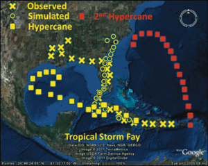
Fig. 33. Comparison of the tracks of observed, simulated, hypercane and second hypercane cases for Tropical Storm Fay.
Fig. 33 shows a similar pattern for Tropical Storm Fay. The observed (x) and simulated (o) cases of Tropical Storm Fay agreed well until near the end of the simulation when the track of the tropical storm continued northward along the east coast. The observed tropical storm tracked westward along the Gulf Coast into Louisiana and Mississippi as it died out. It is likely that the steering winds were so weak near the end of the storm that minor fluctuations could randomly turn the storm in various directions. Like Hurricane Charley the track for the hypercane case (■) diverged strongly, but this time to the west. It traveled into the Gulf of Mexico instead of moving north across Florida. Another hypercane developed to the east of the Dominican Republic and traveled northwestward in the flow set up off the east coast of the United States when the sea-surface temperature was warmed. Several small secondary cyclonic circulations developed over the warm sea surface, but this one amplified more quickly than most and was caught in the main flow. In this case the hypercane moved northward and became trapped at the north end of the broader circulation southeast of the coast of North Carolina. It seems likely that if Tropical Storm Fay had been positioned in a more easterly position when the broad circulation formed it would have also been swept northward along the east coast instead of into the Gulf of Mexico.
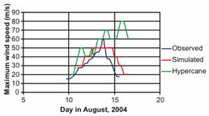
Fig. 34. Comparison of maximum wind speed of observed, simulated, an hypercane cases versus time for Hurricane Charley
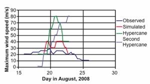
Fig. 35. Comparisons of maximum wind speed of observed, simulated hypercane, and second hypercane cases versus time for Tropical Storm Fay.
Figs. 34 and 35 show comparisons of the observed, simulated, and hypercane maximum wind speeds with time for Hurricane Charley and Tropical Storm Fay. The observed wind speeds were taken at the surface, but the simulated and hypercane winds were taken from the 5 km (~16,000 ft) in the model simulations. In Fig. 34 for Hurricane Charley the maximum wind speed increased in a similar manner for observed, simulated, and hypercane cases. For the observed and simulated cases they also decreased much the same, although the simulated case was slower to do so. For the hypercane case the winds did not decrease, but remained strong through to the end of the case while still caught in the main circulation formed off the east coast.
In Fig. 35 for Tropical Storm Fay the maximum observed wind speed remained uniformly slow and decreased slowly as it began to die when moving over land. In the simulated case the winds were about twice as fast as the observed winds at its greatest, probably because the simulated track of the tropical storm was over warm water more time than the observed track after it left Florida. In the hypercane case the winds increased to a maximum of
80 m/s (160 kts) when it moved into the Gulf of Mexico. However, the winds declined rapidly as the circulation in the Gulf began to weaken. The second hypercane which formed off the coast of the Dominican Republic showed a similar pattern to that of Hypercane Charley as it moved northward in the broad circulation off the east coast. The maximum wind speed increased slowly at first because the hypercane didn’t have a broad region of circulation to draw upon. But, as it began to grow a larger circulation around it the winds continued to increase. It reached a maximum of 80 m/s (160 kts) and didn’t show any indication of declining at the end of the computation. The size of the counterclockwise circulation around Hypercane Fay extended to extreme distances in all directions.
Conclusions and Recommendations
The original intent of this research effort was to demonstrate that warm sea-surface temperatures would intensify a hurricane into a hypercane with stronger winds and heavier precipitation and follow a similar track as the original hurricane. However, the results of this numerical simulation showed otherwise. Hurricanes Charley (2004) and Tropical Storm Fay (2008) were successfully simulated using the NCAR WRF model based on essentially the same intensity and storm tracks between the observed and simulated cases. But, when the sea-surface temperatures were increased from about 30°C (86°F) to 40°C (104°F) the hypercanes which developed did not intensify as much as had been anticipated. Neither did they follow similar tracks like the original hurricanes found in earlier simulations of Hurricane Florence (1988) by Zavacky (2002) and Vardiman (2003).
The apparent reason that Hypercanes Charley and Fay did not intensify as greatly as expected and took widely divergent tracks from the original hurricanes was that a large cyclonic circulation with strong vertical wind shears developed off the southeastern coast of the United States after the sea-surface temperatures of the Atlantic and Gulf of Mexico were heated. This circulation was very much like the one which developed under similar conditions for a simulation of Hypercyclone Gonu off the coast of Saudi Arabia by Vardiman and Brewer (2011). The large cyclonic circulation steered the hypercanes away from Florida and along the direction of the large-scale flow. And, strong vertical wind shears developed in the cyclonic circulation pattern. Vertical wind shear suppresses the intensification of hurricanes.
Large-scale cyclonic flows did not develop during the simulations of Hypercane Florence (Vardiman 2003) because the enhanced sea-surface heating was restricted to a narrow rectangular pattern along the original path of Hurricane Florence. Consequently, the two paths were artificially forced to be the same, and vertical wind shears did not develop, which restricted the intensification of Hypercane Florence.
It is clear from the simulations of Hypercanes Charley and Fay that the large-scale heating which was imposed in the simulations changed the dynamics of the entire coastal region of the southeastern United States. The path and development of the hypercanes were considerably different than for hurricanes. It’s likely that the southeastern United States would be consistently wetter than today if these hypercanes existed after the Genesis Flood because of the movement of moisture and storms from the Atlantic onto the central coast. However, the large cyclonic circulation which is apparently established by the large thermal contrast between the cooler coastlands and the warmer Atlantic and Gulf of Mexico could deter many hypercanes from striking the coast. In addition, the mid-latitude circulation through the central and northern United States also may have been significantly affected.
These findings may be a rich source of new information about the climate not only along the southeastern coast of the United States during the period following the Genesis Flood, but also farther inland where the coastal circulation would likely affect the mid-latitude circulations. It is recommended that additional simulations be conducted using larger-scale domains for periods both of hurricane activity and no hurricane activity. Simulation studies during the hurricane season would help clarify the potential frequency of hurricanes and hypercanes in the southeastern United States. Studies should be done not only in late summer, but also during winter and spring. The temperature contrast between the coastlands and the Atlantic is likely to be even stronger and produce strong coastal circulations even when hurricanes are absent. The likely flow of moisture and storm activity into the central coastlands from North Carolina to New Jersey may well be as significant as from hurricanes and hypercanes farther south. Also, the flow inland to the Appalachians could produce much heavier precipitation there as well.
Acknowledgments
The mesoscale model (WRF) and topographical data used in this study were developed and are maintained by the National Center for Atmospheric Research (NCAR) available at http://www.wrf-model.org. The data for this study were obtained from the Research Data Archive (RDA) which is maintained by the Computational and Information Systems Laboratory (CISL) at the National Center for Atmospheric Research (NCAR). NCAR is sponsored by the National Science Foundation (NSF).
We appreciate the reviewers for studying the manuscript and offering improvements. This research was funded by the National Creation Research Foundation at the Institute for Creation Research.
References
Austin, S. A., J. R. Baumgardner, D. R. Humphreys, A. A. Snelling, L. Vardiman and Wise, K. P. 1994. Catastrophic plate tectonics: A global flood model of earth history. In Proceedings of the Third International Conference on Creationism, ed. R. E. Walsh, pp. 609–621. Pittsburgh, Pennsylvania: Creation Science Fellowship. Retrieved from http://www.icr.org/article/catastrophic-plate-tectonics-flood-model/.
Emanuel, K. A. 1987. The dependence of hurricane intensity on climate. Nature 326:483–485.
Emanuel, K. A. 1991. The theory of hurricanes. Annual Review of Fluid Mechanics 23:179–196. Retrieved from http://www.math.nyu.edu/caos_teaching/hurricanes/emanuel91.pdf.
Emanuel, K. A. 2005. Divine wind: The history and science of hurricanes. Oxford, United Kingdom: Oxford University Press.
Gray, W. M. 1968. Global view of the origin of tropical disturbances and storms. Monthly Weather Review 96, no. 10:669–700.
Heezen, B. and M. Tharp. 1977. Map of the world ocean floor. Office of Naval Research, Columbia University. Retrieved from http://www.columbia.edu/cu/news/06/08/tharp.html.
NCAR. 2003. MM5 model. Retrieved from http://www.mmm.ucar.edu/mm5/.
NCAR. 2007. WRF model. Retrieved from http://www.wrf-model.org/index.php.
Oard, M. 1990. An ice age caused by the Genesis Flood. El Cajon, California: Institute for Creation Research.
UNISYS. 2004a. Retrieved from http://weather.unisys.com/archive/sst/sst-040815.gif.
UNISYS. 2004b. Retrieved from http://weather.unisys.com/hurricane/atlantic/2004H/CHARLEY/track.gif.
UNISYS. 2008a. Retrieved from http://weather.unisys.com/archive/sst/sst-051023.gif.
UNISYS. 2008b. Retrieved from http://weather.unisys.com/hurricane/atlantic/2008H/FAY/track.gif.
Vardiman, L. 2003. Hypercanes following the Genesis Flood. In Proceedings of the Fifth International Conference on Creationism, ed. R. L. Ivey, Jr., pp. 17–28. Pittsburgh, Pennsylvania: Creation Science Fellowship.
Vardiman, L. and W. Brewer. 2010a. Numerical simulation of precipitation in Yosemite National Park with a warm ocean: A pineapple express case study. Answers Research Journal 3:23–36. Retrieved from http://www.answersingenesis.org/articles/arj/v3/n1/yosemite-pineapple-express.
Vardiman, L. and W. Brewer. 2010b. Numerical simulation of precipitation in Yosemite National Park with a warm ocean: Deep upper low and rex blocking pattern case studies. Answers Research Journal 3:119–145. Retrieved from http://www.answersingenesis.org/articles/arj/v3/n1/yosemite-numerical-simulation-precipitation.
Vardiman, L. and W. Brewer. 2010c. Numerical simulation of precipitation in Yellowstone National Park with a warm ocean: Continuous zonal flow, Gulf of Alaska low, and plunging western low case studies. Answers Research Journal 3:209–266. Retrieved from http://www.answersingenesis.org/articles/arj/v3/n1/numerical-simulation-precipitation-yellowstone.
Vardiman, L. and W. Brewer. 2011. A well-watered land: Numerical simulations of a hypercyclone in the Middle East. Answers Research Journal 4:55–74. Retrieved from http://www.answersingenesis.org/articles/arj/v4/n1/well-watered-land.
Zavacky, N. 2002. Hurricane response to extreme sea surface temperatures. Masters Thesis, Institute for Creation Research, San Diego, California.
