The views expressed in this paper are those of the writer(s) and are not necessarily those of the ARJ Editor or Answers in Genesis.
Abstract
Controversy and informed debate are the lifeblood of scientific investigation. Thus Ken Patrick’s 2010 paper on the origin of Uluru is welcome.
Introduction
Controversy and informed debate are the lifeblood of scientific investigation. Thus Ken Patrick’s 2010 paper on the origin of Uluṟu is welcome. Patrick first questions and adversely criticizes several aspects of our work on inselbergs in general, and on Uluṟu in particular (Twidale 1978, 2010; Twidale and Bourne 1978). He also proposes an alternative hypothesis in explanation of Uluṟu.
The So-Called “Conventional” Interpretation
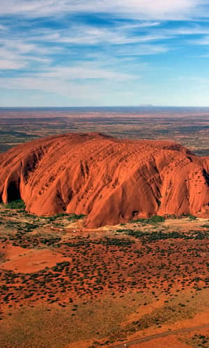
Uluṟu is a beveled arkosic inselberg that has survived the ravages of weathering and erosion over the eons because it was sheared and compressed during the Petermann Orogeny of some 570–530 mya (Stewart 2011). Many minor forms are developed on the summit bevel and steep flanks. They vary in origin. Some are tectonic. The red patina that masks the grey-green arkose, the potholes, and the shallow gashes caused by lightning strikes are epigene, having been formed on exposed rock surfaces. Some are considered to be of subsurface origin. The provenance of others is uncertain.
Subsurface weathering and initiation of forms
Several of the minor features of subsurface origin provide vital evidence concerning the evolution of Uluṟu. However, the reality of subsurface weathering, central to the conventional interpretation (Twidale 1978, 2010; Twidale and Bourne 1978) is denied by Patrick (2010, p. 114), who claims that modern equivalents of flared slopes have “not been observed” in course of formation. Taken literally, this is correct, for most currently developing forms are hidden in the subsurface. And even if the weathering front, the junction between regolith and country rock (Mabbutt 1961), could be observed in situ it would not be possible to detect processes at work. On the other hand, many examples of flared slopes—as well as corestone boulders, pitted surfaces, rock basins, gutters, planate forms, and even bornhardts—have been observed already shaped beneath the natural land surface and now exposed, mostly in artificial excavations such as quarries, road cuttings, and local reservoirs (Hassenfratz 1791; Twidale 1962, 2002).
Patrick understands that there is only one zone of flared slopes on Uluṟu. This is not so. Two zones, located 4–5 m and 35–60 m above present plain level, and comprising assemblages of forms initiated at the weathering front in the shallow subsurface, are preserved on the southern face of Uluṟu. Flared slopes dominate the lower, and gaping-mouth caves the higher, but both of these forms are represented in both zones (pace Patrick 2010, pp. 110–111). At several sites, at Uluṟu and elsewhere, flared slopes merge laterally with cylindrical footcaves, shelters or tafoni, and with angular breaks of slopes. Unlike the flared slopes and other forms noted, however, no deep indents have so far been located in subsurface exposures.
Nevertheless, the gaping-mouth caves are coincident with flared slopes and can be attributed either to post-exposure weathering or to intense weathering just above the weathering front, which is where initial breakdown of the country rock occurs (Hutton Lindsay, and Twidale 1977; Twidale 1986). The latter suggestion is more likely but is speculative.
The Mutitjulu Arkose
Patrick (2010, p. 110 et seq.) expresses concerns over the origin and fate of the arkose and related arenaceous and rudaceous rocks in which Uluṟu, Kata Tjuṯa and other residuals surviving in the southern Amadeus Basin are shaped. The thick sequences of fan sediments are impressive but comprehensible as the work of rivers acting on uplands unprotected by vegetation and flowing to a subsiding basin. The arkosic (and rudaceous) debris was derived from the precursors of the Musgrave, Everard, and associated ranges, which, as indicated by the exposed stocks and batholiths, are deeply eroded remnants. That Uluṟu was left in relief implies the stripping of a large volume of detritus that was transported by streams and rivers, the predecessors of the modern Finke and Palmer systems, and deposited in the eastern Amadeus and the western Lake Eyre basins.
The arkose is impermeable, partly because of lithification and compaction resulting from the great thickness and weight of superincumbent strata. In addition, the compartment of rock in which Uluṟu is shaped has survived because it is, or has been, in compression. This is suggested by the occurrence of sheet structures, like the Kangaroo Tail, and triangular wedges exposed in some footcaves and elsewhere (for example, Twidale et al. 1996; Twidale and Sved 1978).
Chronology
Patrick offers only a hint as to the timetable of events. When referring to his Flood (for example, 2010, p. 114) he uses upper case ‘F’. As this denotes the Noachian Flood, is it to be viewed in the context of Ussherian time, with the whole evolution of Uluṟu having been accomplished in the last 6,000–7,000 years?
The conventional interpretation calls for a much longer chronology of events. It is not possible directly to date older erosional land surfaces. Instead, a reasoned reconstruction has been derived based on modern congeners and on local and regional evidence, with particular reference to the Macdonnell and Everard ranges and associated uplands (Twidale 2007). The summit bevel of Uluṟu is considered to be of Maastrichtian age. The low rates of denudation typical of much of Australia (Patrick 2010, p. 113) surely favor the conservation of such exposed landforms. Once exposed, the crest of Uluṟu was stable, but subsurface moisture attack continued apace, wearing back and steepening the bedrock surface, which after stripping also stood unchanged save in detail.
The weathering responsible for the precipitous flanks of Uluṟu is considered to have taken place in the Paleocene and Eocene, because it is associated with silcrete, which in the Lake Eyre basin has been dated stratigraphically as of that age (Mabbutt 1965; Wopfner Callen, and Harris 1974). At this time the climate of central Australia was warm and humid (for example, Benbow et al. 1995) favoring intense weathering by groundwaters rich in biota and organic chemicals. A prolonged phase of subsurface attack is implied by the depth of weathering. Dissection of the silcreted surface and exposure of the steepened face of Uluṟu must have occurred in post Eocene times and considerable thicknesses of Middle and Late Tertiary strata are recorded in the Lake Eyre basin (for example, Callen, Alley, and Greenwood 1995).
Cascades of potholes
These are still developing and, as demonstrated during the occasional heavy rains, are caused by runoff. As photographs clearly show, the depressions increase in size downslope, presumably reflecting both increasing volumes of water and abrasive sand included as load.
The Patrick Model
Patrick (2010, p.113 et seq.) proposes a three-part development of Uluṟu as a preferred alternative to the conventional hypothesis. First, a “cataclysmic watery” event, a deluge, deposited the arkose, and, second, the receding floodwaters shaped the ancestral Uluṟu. Third, torrential rains caused the inundation of the Amadeus Basin and the formation of a lake “several tens of meters” deep. Its level changed in time but wave action at the margins modified the southern flank of Uluṟu to produce the distinctive 30–65 m and 4–5 m landform assemblages.
For the reader there are problems with the author’s use of words and phrases. For instance, what is a temporal lake (Patrick 2010, p. 113); what is a land breach (Patrick 2010, p. 108); how can a watershed scour out a valley (Patrick 2010, p. 108); and how can a subsiding lake achieve regional planation (Patrick 2010, p. 114)? Why is there any necessity to “confess” to postulating a subsurface origin for flared slopes (Patrick 2010, p. 111)? Nevertheless, it is hoped that the correct construction has been placed on the text.
The critical aspect of the Patrick alternative is his suggested development of a deep lake. Examination of available topographic maps suggests it would have occupied most of the present Amadeus Basin. But what blocked the lake, and where are the lake deposits and associated fossils? The plains around Uluṟu are underlain by sequences of mixed sediments (Twidale 1978) with a cover of alluvial and wind-blown sand. Thus, it is simply incorrect to state that lacustrine beds 180 m thick (and more) have been located in the vicinity of Uluṟu (Patrick 2010, pp. 117–118).
Furthermore, although Patrick (2010, pp. 116–118) attributes the landform assemblages in the 4–5 m and 30–65 m zones to wave action, neither displays forms and features typical of coastal notches. The relative significance for coastal erosion of various physical, chemical and biotic agents varies from place to place but even if waves had been active and more effective, why was their effect concentrated on—almost confined to—the southern face of the inselberg? Also, lignites, which consist of compressed vegetation, are minor components of several sequences and imply swampy conditions that are hardly conducive to wave action.
Are all flared slopes to be attributed to wave action? The temptingly-named Wave Rock, one of the most spectacular of flared forms, is located in the southwest of Western Australia (Twidale 1968), but in a region renowned for its well-established paleodrainage system (Van de Graaff et al. 1977). Saline fluvial sediments occur in these channels, but the region is notably lacking in widespread lacustrine beds. Surely, the flared slopes located in hilly or mountainous terrains such as the Californian Sierra Nevada or the Victorian Alps cannot be caused by wave action.
Apart from such difficulties of commission, Patrick’s hypothesis leaves much unexplained. For example, the survival of an Uluṟu, which on three sides protrudes from a platform cut in arkose either exposed or covered by a thin veneer of sand, is not broached. With the possible exception of Mutitjulu and other waterholes located within structural clefts on the southern face, there is no evidence of sapping (Patrick 2010, p. 116) in the form of springs or seepages around the base of Uluṟu. Nor are they likely to develop generally in steeply dipping impermeable strata. No explanation is offered for the preferential concentration of decorations, including the features attributed to a sapping on the southern face of the residual. This distribution is susceptible of explanation by subsurface weathering, given the demonstrated occurrence of moisture contained in the sediments that border the southern flank of Uluṟu. It is not accounted for by postulating the existence of a lake that would wash equally against all sides of the residual.
Conclusion
The so-called conventional explanation based in subsurface initiation and later episodic exposure (Twidale and Bourne 1975) is compatible with the local and regional evidence—as far as it goes. Unfortunately, there are no relevant deep exposures around Uluṟu, so that the inferred subsurface processes and the resultant bedrock forms cannot be observed. Instead, rational inferences have been drawn based on analyses of regoliths adjacent to the weathering front. Again, it is not possible either to examine the rock that has been eroded from all around Uluṟu to determine what rendered it more susceptible, or to test the composition of Eocene groundwaters that are suggested to have achieved the deep weathering responsible for the recession and steepening of the flanks of Uluṟu. And so on—all explanations inevitably involve extrapolation and informed speculation.
Nevertheless, no matter how imaginative they may be, hypotheses must have some basis in fact. One could, for instance, be highly original and propose that Uluṟu has been shaped by glaciers and that glacial till or drift is widely distributed in the Basin. But disregarding for the moment the question of how glaciers erode, there is no supporting evidence on which either to base or to test such a suggestion.
The two-stage hypothesis involving subsurface initiation and subsequent exposure is based in data and concepts that begin coherently to explain the morphology of Uluṟu and environs. Like most geomorphological constructions the interpretation is in the nature of a work in progress, but nevertheless acceptable pro tempore.
References
Benbow M. C., N. F. Alley, R. A. Callen, and D. R. Greenwood. 1995. Tertiary. Geological history and palaeoclimate. In The geology of South Australia, vol. 2, The Phanerozoic, ed. J. F. Drexel and W. V. Preiss, bulletin 54, pp. 208–217. Adelaide: Geological Survey of South Australia.
Callen, R. A., N. F. Alley, and D. R. Greenwood. 1995. Tertiary. Lake Eyre Basin. In The geology of South Australia, vol. 2, The Phanerozoic, ed. J. F. Drexel and W. V. Preiss, bulletin 54, pp. 188–207. Adelaide: Geological Survey of South Australia.
Hassenfratz, J-H. 1791. Sur l’arrangement de plusieurs gros blocs de différentes pierres que l’on observe dans les montagnes. Annales de Chimie 11:95–107.
Hutton, J. T., D. S. Lindsay, and C. R. Twidale. 1977. The weathering of norite at Black Hill, South Australia. Journal of the Geological Society of Australia 24:37–50.
Mabbutt, J. A. 1961. ‘Basal surface’ or ‘weathering front’. Proceedings of the Geologists’ Association of London 72:357–358.
Mabbutt, J. A. 1965. The weathered land surface in central Australia. Zeitschrift für Geomorphologie 9:82–114.
Patrick, K. 2010. Geomorphology of Uluṟu, Australia. Answers Research Journal 3:107–118.
Stewart, A. 2011. New cross-sections through Uluṟu and Kata Tjuṯa. The Australian Geologist 159:20–22.
Twidale, C. R. 1962. Steepened margins of inselbergs from north-western Eyre Peninsula, South Australia. Zeitschrift für Geomorphologie 6: 51–69.
Twidale, C. R. 1968. Origin of Wave Rock, Hyden, Western Australia. Transactions of the Royal Society of South Australia 92:115–123.
Twidale, C. R. 1978. On the origin of Ayers Rock, central Australia. Zeitschrift für Geomorphologie Supplement Band 31:177–206.
Twidale, C. R. 1986. Granite landform evolution: factors and implications. Geologische Rundschau 75:769–779.
Twidale, C. R. 2002. The two-stage concept of landform and landscape development involving etching: origin, development and implications of an idea. Earth–Science Reviews 57:37–74.
Twidale, C. R. 2007. Ancient Australian landscapes. Sydney: Rosenberg.
Twidale, C. R. 2010. Uluṟu (Ayers Rock) and Kata Tjuṯa (The Olgas): Inselbergs of central Australia. In Geomorphological landscapes of the world, ed. P. Migon, pp. 321–332. Vienna: Springer.
Twidale, C. R., and J. A. Bourne. 1975. Episodic exposure of inselbergs. Geological Society of America Bulletin 86:1473–1481.
Twidale, C. R., and J. A. Bourne. 1978. Bornhardts developed in sedimentary rocks, central Australia. The South African Geographer 6:35–51.
Twidale, C. R., and G. Sved. 1978. Minor granite landforms associated with the release of compressive stress. Australian Geographical Studies 16:161–174.
Twidale, C. R., J. R. Vidal Romani, E. M. Campbell, and J. D. Centeno. 1996. Sheet fractures: response to erosional offloading or to tectonic stress? Zeitschrift für Geomorphologie Supplementband 106:1–24.
Van de Graaff, W. J. E., R. W. A. Crowe, J. A. Bunting, and M. J. Jackson. 1977. Relict Early Cainozoic drainages in arid Western Australia. Zeitschrift für Geomorphologie 21:379–400.
Wopfner, H., R. Callen, and W. K. Harris. 1974. The Lower Tertiary Eyre Formation of the southwestern Great Artesian Basin. Journal of the Geological Society of Australia 21:17–51.
